Samokov geodata
Samokov (Sofia) is a populated place; located in Bulgaria in Europe/Sofia (GMT+3) time zone. With population of 26,765 people, there are 35 cities with bigger population in this country. Compared to other cities in Bulgaria, 71.3% of cities are located further ↑North; 80% of cities are located further →East and 96.3% of cities have lower elevation than Samokov. Note1


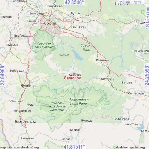
Samokov GPS coordinates[2]
42° 20' 13.2" North, 23° 33' 10.08" East
| Map corner | latitude | longitude |
|---|---|---|
| Upper-left | 42.8546°, | 22.84968° |
| Center: | 42.337°, | 23.5528° |
| Lower-right: | 41.81511°, | 24.25593° |
| Map W x H: | 115.6×115.6 km | = 71.8×71.8mi |
| max Lat: | 44.16214° ⇑71.3% North |
| Samokov: | 42.337° |
| min Lat: | ⇓28.7% South 41.32715° |
| min Long | Samokov | max Long |
| 22.52139° | 23.5528° | 28.53429° |
| W 20%⇐ | ⇒80% E |
Elevation
Elevation of Samokov is 945 m = 3100 ft, and this is 628.4 m = 2062 ft above average elevation for this country.
| Max E: |
1221 m = 4006 ft | 3.7% |
| Samokov | 945 m 3100 ft | |
| Avg. | 316.6 m = 1039 ft | |
Min E: |
1 m = 3 ft | 96.3% |
See also: Bulgaria elevation on elevation.city.
Geographical zone
Samokov is located in North temperate zone (between Tropic of Cancer and the Arctic Circle). Distance of this Northern Tropic circle is 2101.5 km =1305.8 mi to South.| Distance of | km | miles | from Samokov |
|---|---|---|---|
| North Pole | 5299.6 | 3293 | to North |
| Arctic Circle | 2693.7 | 1673.8 | to North |
| Tropic Cancer | 2101.5 | 1305.8 | to South |
| Equator | 4707.4 | 2925 | to South |


Nearby cities:
15 places around Samokov: (largest is in red/bold)
• Belitsa
42.3 km =26.3 mi,  177°
177°
• Belovo
40.9 km =25.4 mi,  109°
109°
• Bobov Dol
45.2 km =28.1 mi,  273°
273°
• Buhovo
47.8 km =29.7 mi,  1°
1°
• Dolna Banya
18.1 km =11.2 mi,  103°
103°
• Dupnitsa
36.7 km =22.8 mi,  257°
257°
• Elin Pelin
36.9 km =22.9 mi,  6°
6°
• Gorna Malina
40.4 km =25.1 mi,  17°
17°
• Ihtiman
24.2 km =15 mi,  63°
63°
• Lesichovo
46 km =28.6 mi,  87°
87°
• Porominovo
48.1 km =29.9 mi,  233°
233°
• Rila
41.3 km =25.7 mi,  236°
236°
• Sapareva Banya
24.3 km =15.1 mi, 255°
• Sofia
44.2 km =27.5 mi,  334°
334°
• Yakoruda
36.3 km =22.6 mi,  162°
162°
Sources, notices
• [Note1] Compared only with cities in Bulgaria existing in our database
• [Src1] Map data: © OpenStreetMap contributors (CC-BY-SA)
• [Src2] Other city data from geonames.org with taken over terms of usage.
• [Src3] Geographical zone / Annual Mean Temperature by Robert A. Rohde @ Wikipedia
