Dupnitsa geodata
Dupnitsa (Kyustendil) is a populated place; located in Bulgaria in Europe/Sofia (GMT+3) time zone. With population of 34,764 people, there are 29 cities with bigger population in this country. Compared to other cities in Bulgaria, 74.3% of cities are located further ↑North; 88.7% of cities are located further →East and 78.7% of cities have lower elevation than Dupnitsa. Note1


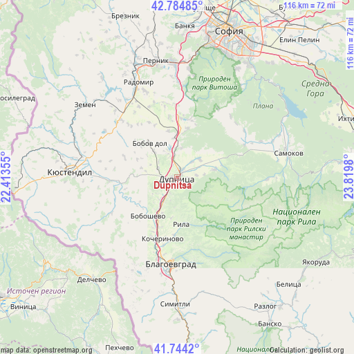
Dupnitsa GPS coordinates[2]
42° 16' 0.012" North, 23° 7' 0.012" East
| Map corner | latitude | longitude |
|---|---|---|
| Upper-left | 42.78485°, | 22.41355° |
| Center: | 42.26667°, | 23.11667° |
| Lower-right: | 41.7442°, | 23.8198° |
| Map W x H: | 115.7×115.7 km | = 71.9×71.9mi |
| max Lat: | 44.16214° ⇑74.3% North |
| Dupnitsa: | 42.26667° |
| min Lat: | ⇓25.7% South 41.32715° |
| min Long | Dupnitsa | max Long |
| 22.52139° | 23.11667° | 28.53429° |
| W 11.3%⇐ | ⇒88.7% E |
Elevation
Elevation of Dupnitsa is 512 m = 1680 ft, and this is 195.4 m = 641 ft above average elevation for this country.
| Max E: |
1221 m = 4006 ft | 21.3% |
| Dupnitsa | 512 m 1680 ft | |
| Avg. | 316.6 m = 1039 ft | |
Min E: |
1 m = 3 ft | 78.7% |
See also: Bulgaria elevation on elevation.city.
Geographical zone
Dupnitsa is located in North temperate zone (between Tropic of Cancer and the Arctic Circle). Distance of this Northern Tropic circle is 2093.7 km =1301 mi to South.| Distance of | km | miles | from Dupnitsa |
|---|---|---|---|
| North Pole | 5307.4 | 3297.9 | to North |
| Arctic Circle | 2701.6 | 1678.7 | to North |
| Tropic Cancer | 2093.7 | 1301 | to South |
| Equator | 4699.6 | 2920.2 | to South |


Nearby cities:
15 places around Dupnitsa: (largest is in red/bold)
• Batanovtsi
39 km =24.2 mi,  340°
340°
• Blagoevgrad
27.8 km =17.3 mi,  182°
182°
• Boboshevo
15.8 km =9.8 mi,  216°
216°
• Bobov Dol
14.2 km =8.8 mi,  318°
318°
• Borovets
19.6 km =12.2 mi,  203°
203°
• Kocherinovo
20.9 km =13 mi,  193°
193°
• Kyustendil
35.1 km =21.8 mi,  273°
273°
• Nevestino
21.8 km =13.5 mi, 266°
• Pernik
37.7 km =23.4 mi,  349°
349°
• Porominovo
21.3 km =13.2 mi, 186°
• Radomir
33.4 km =20.8 mi, 338°
• Rila
14.9 km =9.3 mi,  174°
174°
• Samokov
36.7 km =22.8 mi,  77°
77°
• Sapareva Banya
12.5 km =7.8 mi, 81°
• Zemen
38.3 km =23.8 mi,  308°
308°
Sources, notices
• [Note1] Compared only with cities in Bulgaria existing in our database
• [Src1] Map data: © OpenStreetMap contributors (CC-BY-SA)
• [Src2] Other city data from geonames.org with taken over terms of usage.
• [Src3] Geographical zone / Annual Mean Temperature by Robert A. Rohde @ Wikipedia
