Belitsa geodata
Belitsa (Blagoevgrad) is a populated place; located in Bulgaria in Europe/Sofia (GMT+3) time zone. With population of 3,166 people, there are 189 cities with bigger population in this country. Compared to other cities in Bulgaria, 86% of cities are located further ↑North; 79% of cities are located further →East and 96.7% of cities have lower elevation than Belitsa. Note1


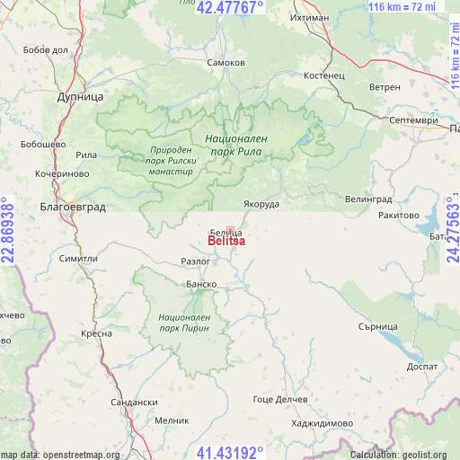
Belitsa GPS coordinates[2]
41° 57' 24.984" North, 23° 34' 21" East
| Map corner | latitude | longitude |
|---|---|---|
| Upper-left | 42.47767°, | 22.86938° |
| Center: | 41.95694°, | 23.5725° |
| Lower-right: | 41.43192°, | 24.27563° |
| Map W x H: | 116.3×116.3 km | = 72.3×72.3mi |
| max Lat: | 44.16214° ⇑86% North |
| Belitsa: | 41.95694° |
| min Lat: | ⇓14% South 41.32715° |
| min Long | Belitsa | max Long |
| 22.52139° | 23.5725° | 28.53429° |
| W 21%⇐ | ⇒79% E |
Elevation
Elevation of Belitsa is 966 m = 3169 ft, and this is 649.4 m = 2131 ft above average elevation for this country.
| Max E: |
1221 m = 4006 ft | 3.3% |
| Belitsa | 966 m 3169 ft | |
| Avg. | 316.6 m = 1039 ft | |
Min E: |
1 m = 3 ft | 96.7% |
See also: Bulgaria elevation on elevation.city.
Geographical zone
Belitsa is located in North temperate zone (between Tropic of Cancer and the Arctic Circle). Distance of this Northern Tropic circle is 2059.3 km =1279.6 mi to South.| Distance of | km | miles | from Belitsa |
|---|---|---|---|
| North Pole | 5341.9 | 3319.3 | to North |
| Arctic Circle | 2736 | 1700.1 | to North |
| Tropic Cancer | 2059.3 | 1279.6 | to South |
| Equator | 4665.2 | 2898.8 | to South |


Nearby cities:
15 places around Belitsa: (largest is in red/bold)
• Bansko
14.9 km =9.3 mi,  207°
207°
• Blagoevgrad
39.6 km =24.6 mi,  279°
279°
• Dolna Banya
41.4 km =25.7 mi,  22°
22°
• Kresna
42.9 km =26.7 mi,  234°
234°
• Porominovo
42.3 km =26.3 mi,  288°
288°
• Rakitovo
42.7 km =26.5 mi,  85°
85°
• Razlog
11.7 km =7.3 mi, 227°
• Rila
41.2 km =25.6 mi,  298°
298°
• Samokov
42.3 km =26.3 mi,  357°
357°
• Sapareva Banya
44.2 km =27.5 mi,  325°
325°
• Sarnitsa
44.6 km =27.7 mi,  123°
123°
• Simitli
38.6 km =24 mi,  257°
257°
• Stara Kresna
36.6 km =22.7 mi,  241°
241°
• Velingrad
35.5 km =22.1 mi,  77°
77°
• Yakoruda
12 km =7.5 mi,  50°
50°
Sources, notices
• [Note1] Compared only with cities in Bulgaria existing in our database
• [Src1] Map data: © OpenStreetMap contributors (CC-BY-SA)
• [Src2] Other city data from geonames.org with taken over terms of usage.
• [Src3] Geographical zone / Annual Mean Temperature by Robert A. Rohde @ Wikipedia
