Yakoruda geodata
Yakoruda (Blagoevgrad) is a populated place; located in Bulgaria in Europe/Sofia (GMT+3) time zone. With population of 6,008 people, there are 120 cities with bigger population in this country. Compared to other cities in Bulgaria, 84% of cities are located further ↑North; 78% of cities are located further →East and 97.7% of cities have lower elevation than Yakoruda. Note1


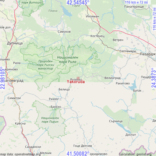
Yakoruda GPS coordinates[2]
42° 1' 31.008" North, 23° 41' 3.012" East
| Map corner | latitude | longitude |
|---|---|---|
| Upper-left | 42.54545°, | 22.98105° |
| Center: | 42.02528°, | 23.68417° |
| Lower-right: | 41.50082°, | 24.3873° |
| Map W x H: | 116.2×116.2 km | = 72.2×72.2mi |
| max Lat: | 44.16214° ⇑84% North |
| Yakoruda: | 42.02528° |
| min Lat: | ⇓16% South 41.32715° |
| min Long | Yakoruda | max Long |
| 22.52139° | 23.68417° | 28.53429° |
| W 22%⇐ | ⇒78% E |
Elevation
Elevation of Yakoruda is 1028 m = 3373 ft, and this is 711.4 m = 2334 ft above average elevation for this country.
| Max E: |
1221 m = 4006 ft | 2.3% |
| Yakoruda | 1028 m 3373 ft | |
| Avg. | 316.6 m = 1039 ft | |
Min E: |
1 m = 3 ft | 97.7% |
See also: Bulgaria elevation on elevation.city.
Geographical zone
Yakoruda is located in North temperate zone (between Tropic of Cancer and the Arctic Circle). Distance of this Northern Tropic circle is 2066.9 km =1284.3 mi to South.| Distance of | km | miles | from Yakoruda |
|---|---|---|---|
| North Pole | 5334.3 | 3314.6 | to North |
| Arctic Circle | 2728.4 | 1695.3 | to North |
| Tropic Cancer | 2066.9 | 1284.3 | to South |
| Equator | 4672.8 | 2903.5 | to South |


Nearby cities:
15 places around Yakoruda: (largest is in red/bold)
• Bansko
26.3 km =16.3 mi,  217°
217°
• Batak
45.1 km =28 mi,  101°
101°
• Belitsa
12 km =7.5 mi,  230°
230°
• Belovo
34.7 km =21.6 mi,  53°
53°
• Blagoevgrad
48.3 km =30 mi,  268°
268°
• Dolna Banya
31.3 km =19.4 mi,  12°
12°
• Ihtiman
46.7 km =29 mi, 13°
• Rakitovo
33.5 km =20.8 mi, 96°
• Razlog
23.7 km =14.7 mi, 229°
• Rila
47 km =29.2 mi,  284°
284°
• Samokov
36.3 km =22.6 mi,  342°
342°
• Sapareva Banya
44.8 km =27.8 mi,  309°
309°
• Sarnitsa
42.6 km =26.5 mi,  138°
138°
• Septemvri
42.2 km =26.2 mi,  60°
60°
• Velingrad
25.4 km =15.8 mi,  89°
89°
Sources, notices
• [Note1] Compared only with cities in Bulgaria existing in our database
• [Src1] Map data: © OpenStreetMap contributors (CC-BY-SA)
• [Src2] Other city data from geonames.org with taken over terms of usage.
• [Src3] Geographical zone / Annual Mean Temperature by Robert A. Rohde @ Wikipedia
