Pavlikeni geodata
Pavlikeni (Veliko Tarnovo) is a populated place; located in Bulgaria in Europe/Sofia (GMT+3) time zone. With population of 12,214 people, there are 68 cities with bigger population in this country. Compared to other cities in Bulgaria, 67.7% of cities are located further ↓South; 54.3% of cities are located further ←West and 67% of cities have higher elevation than Pavlikeni. Note1


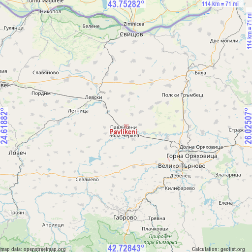
Pavlikeni GPS coordinates[2]
43° 14' 34.008" North, 25° 19' 18.984" East
| Map corner | latitude | longitude |
|---|---|---|
| Upper-left | 43.75282°, | 24.61882° |
| Center: | 43.24278°, | 25.32194° |
| Lower-right: | 42.72843°, | 26.02507° |
| Map W x H: | 113.9×113.9 km | = 70.8×70.8mi |
| max Lat: | 44.16214° ⇑32.3% North |
| Pavlikeni: | 43.24278° |
| min Lat: | ⇓67.7% South 41.32715° |
| min Long | Pavlikeni | max Long |
| 22.52139° | 25.32194° | 28.53429° |
| W 54.3%⇐ | ⇒45.7% E |
Elevation
Elevation of Pavlikeni is 157 m = 515 ft, and this is 159.6 m = 524 ft below average elevation for this country.
| Max E: |
1221 m = 4006 ft | 67% |
| Avg. | 316.6 m = 1039 ft | |
| Pavlikeni | 157 m = 515 ft | |
Min E: |
1 m = 3 ft | 33% |
See also: Bulgaria elevation on elevation.city.
Geographical zone
Pavlikeni is located in North temperate zone (between Tropic of Cancer and the Arctic Circle). Distance of this Northern Tropic circle is 2202.2 km =1368.4 mi to South.| Distance of | km | miles | from Pavlikeni |
|---|---|---|---|
| North Pole | 5198.9 | 3230.4 | to North |
| Arctic Circle | 2593 | 1611.2 | to North |
| Tropic Cancer | 2202.2 | 1368.4 | to South |
| Equator | 4808.1 | 2987.6 | to South |


Nearby cities:
15 places around Pavlikeni: (largest is in red/bold)
• Byala Cherkva
5.1 km =3.2 mi,  200°
200°
• Debelets
33.4 km =20.8 mi,  134°
134°
• Dryanovo
32 km =19.9 mi,  156°
156°
• Gabrovo
40.9 km =25.4 mi,  178°
178°
• Gorna Oryahovitsa
33.3 km =20.7 mi,  112°
112°
• Kilifarevo
38.4 km =23.9 mi,  138°
138°
• Letnitsa
21.5 km =13.4 mi,  290°
290°
• Levski
20.6 km =12.8 mi,  312°
312°
• Lyaskovets
36.1 km =22.4 mi, 113°
• Parvomaytsi
28.5 km =17.7 mi, 111°
• Polski Trambesh
29.2 km =18.1 mi,  60°
60°
• Pordim
41.3 km =25.7 mi, 292°
• Sevlievo
29.5 km =18.3 mi,  215°
215°
• Suhindol
12.7 km =7.9 mi,  243°
243°
• Veliko Tŭrnovo
30.7 km =19.1 mi, 125°
Sources, notices
• [Note1] Compared only with cities in Bulgaria existing in our database
• [Src1] Map data: © OpenStreetMap contributors (CC-BY-SA)
• [Src2] Other city data from geonames.org with taken over terms of usage.
• [Src3] Geographical zone / Annual Mean Temperature by Robert A. Rohde @ Wikipedia
