Iskar geodata
Iskar (Pleven) is a seat of a second-order administrative division; located in Bulgaria in Europe/Sofia (GMT+3) time zone. In our database, there are 288 cities with bigger population. Compared to other cities in Bulgaria, 87.7% of cities are located further ↓South; 61% of cities are located further →East and 87.3% of cities have higher elevation than Iskar. Note1


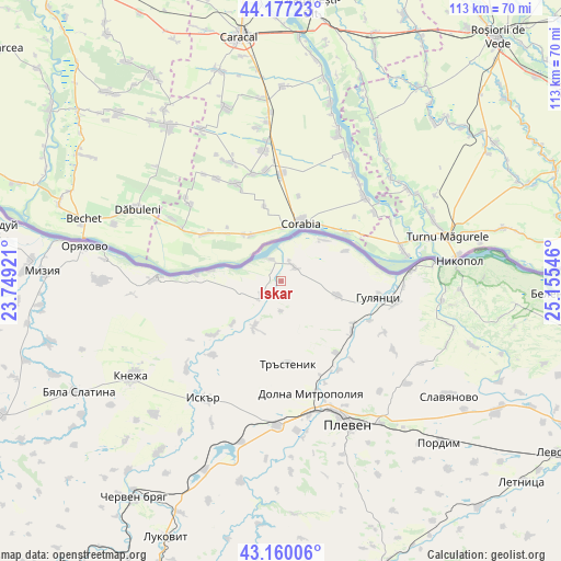
Iskar GPS coordinates[2]
43° 40' 14.88" North, 24° 27' 8.388" East
| Map corner | latitude | longitude |
|---|---|---|
| Upper-left | 44.17723°, | 23.74921° |
| Center: | 43.6708°, | 24.45233° |
| Lower-right: | 43.16006°, | 25.15546° |
| Map W x H: | 113.1×113.1 km | = 70.3×70.3mi |
| max Lat: | 44.16214° ⇑12.3% North |
| Iskar: | 43.6708° |
| min Lat: | ⇓87.7% South 41.32715° |
| min Long | Iskar | max Long |
| 22.52139° | 24.45233° | 28.53429° |
| W 39%⇐ | ⇒61% E |
Elevation
Elevation of Iskar is 50 m = 164 ft, and this is 266.6 m = 875 ft below average elevation for this country.
| Max E: |
1221 m = 4006 ft | 87.3% |
| Avg. | 316.6 m = 1039 ft | |
| Iskar | 50 m = 164 ft | |
Min E: |
1 m = 3 ft | 12.7% |
See also: Bulgaria elevation on elevation.city.
Geographical zone
Iskar is located in North temperate zone (between Tropic of Cancer and the Arctic Circle). Distance of this Northern Tropic circle is 2249.8 km =1398 mi to South.| Distance of | km | miles | from Iskar |
|---|---|---|---|
| North Pole | 5151.3 | 3200.9 | to North |
| Arctic Circle | 2545.4 | 1581.6 | to North |
| Tropic Cancer | 2249.8 | 1398 | to South |
| Equator | 4855.7 | 3017.2 | to South |


Nearby cities:
15 places around Iskar: (largest is in red/bold)
• Belene
54.3 km =33.7 mi,  92°
92°
• Byala Slatina
47.6 km =29.6 mi,  241°
241°
• Cherven Bryag
52.8 km =32.8 mi,  214°
214°
• Dolna Mitropolia
23.6 km =14.7 mi,  163°
163°
• Dolni Dabnik
30.1 km =18.7 mi,  182°
182°
• Gulyantsi
19.7 km =12.2 mi,  99°
99°
• Iskar
28.7 km =17.8 mi, 211°
• Knezha
35.3 km =21.9 mi, 237°
• Koynare
44 km =27.3 mi,  215°
215°
• Mizia
48.2 km =30 mi,  272°
272°
• Nikopol
35.8 km =22.2 mi,  83°
83°
• Oryahovo
40.2 km =25 mi,  280°
280°
• Pleven
31.2 km =19.4 mi,  154°
154°
• Pordim
45.3 km =28.1 mi,  134°
134°
• Slavyanovo
40.4 km =25.1 mi,  124°
124°
Sources, notices
• [Note1] Compared only with cities in Bulgaria existing in our database
• [Src1] Map data: © OpenStreetMap contributors (CC-BY-SA)
• [Src2] Other city data from geonames.org with taken over terms of usage.
• [Src3] Geographical zone / Annual Mean Temperature by Robert A. Rohde @ Wikipedia
