Glavinitsa geodata
Glavinitsa (Silistra) is a populated place; located in Bulgaria in Europe/Sofia (GMT+3) time zone. With population of 2,220 people, there are 226 cities with bigger population in this country. Compared to other cities in Bulgaria, 96.3% of cities are located further ↓South; 79.3% of cities are located further ←West and 77.7% of cities have higher elevation than Glavinitsa. Note1


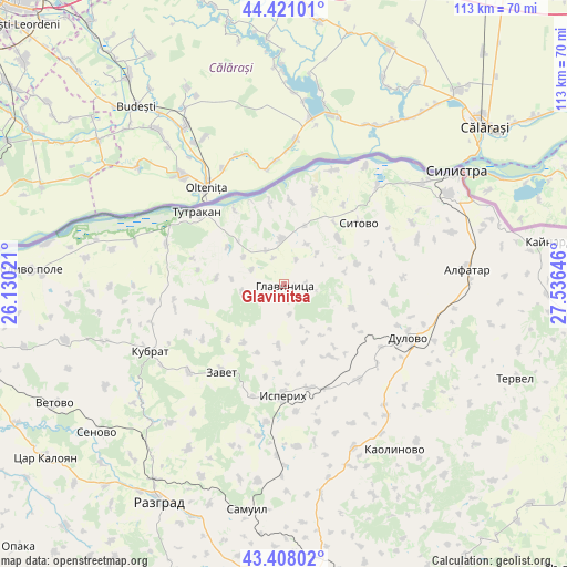
Glavinitsa GPS coordinates[2]
43° 55' 0.012" North, 26° 49' 59.988" East
| Map corner | latitude | longitude |
|---|---|---|
| Upper-left | 44.42101°, | 26.13021° |
| Center: | 43.91667°, | 26.83333° |
| Lower-right: | 43.40802°, | 27.53646° |
| Map W x H: | 112.6×112.6 km | = 70×70mi |
| max Lat: | 44.16214° ⇑3.7% North |
| Glavinitsa: | 43.91667° |
| min Lat: | ⇓96.3% South 41.32715° |
| min Long | Glavinitsa | max Long |
| 22.52139° | 26.83333° | 28.53429° |
| W 79.3%⇐ | ⇒20.7% E |
Elevation
Elevation of Glavinitsa is 108 m = 354 ft, and this is 208.6 m = 684 ft below average elevation for this country.
| Max E: |
1221 m = 4006 ft | 77.7% |
| Avg. | 316.6 m = 1039 ft | |
| Glavinitsa | 108 m = 354 ft | |
Min E: |
1 m = 3 ft | 22.3% |
See also: Bulgaria elevation on elevation.city.
Geographical zone
Glavinitsa is located in North temperate zone (between Tropic of Cancer and the Arctic Circle). Distance of this Northern Tropic circle is 2277.2 km =1415 mi to South.| Distance of | km | miles | from Glavinitsa |
|---|---|---|---|
| North Pole | 5124 | 3183.9 | to North |
| Arctic Circle | 2518.1 | 1564.7 | to North |
| Tropic Cancer | 2277.2 | 1415 | to South |
| Equator | 4883.1 | 3034.2 | to South |


Nearby cities:
15 places around Glavinitsa: (largest is in red/bold)
• Alfatar
36.5 km =22.7 mi,  85°
85°
• Dulovo
27.7 km =17.2 mi,  113°
113°
• Gorichevo
31.6 km =19.6 mi,  256°
256°
• Isperih
22.2 km =13.8 mi,  180°
180°
• Kaolinovo
40.4 km =25.1 mi,  145°
145°
• Kubrat
29.8 km =18.5 mi,  243°
243°
• Medovene
30.4 km =18.9 mi, 236°
• Samuil
45 km =28 mi,  188°
188°
• Senovo
47.8 km =29.7 mi,  231°
231°
• Silistra
40.8 km =25.4 mi,  56°
56°
• Sitovo
19.3 km =12 mi,  50°
50°
• Tochilari
30.3 km =18.8 mi, 255°
• Tutrakan
23 km =14.3 mi,  309°
309°
• Venets
41.6 km =25.8 mi,  168°
168°
• Zavet
21.3 km =13.2 mi,  215°
215°
Sources, notices
• [Note1] Compared only with cities in Bulgaria existing in our database
• [Src1] Map data: © OpenStreetMap contributors (CC-BY-SA)
• [Src2] Other city data from geonames.org with taken over terms of usage.
• [Src3] Geographical zone / Annual Mean Temperature by Robert A. Rohde @ Wikipedia
