Tutrakan geodata
Tutrakan (Silistra) is a seat of a second-order administrative division; located in Bulgaria in Europe/Sofia (GMT+3) time zone. With population of 10,022 people, there are 77 cities with bigger population in this country. Compared to other cities in Bulgaria, 99% of cities are located further ↓South; 76.7% of cities are located further ←West and 77% of cities have higher elevation than Tutrakan. Note1


Tutrakan GPS coordinates[2]
44° 2' 56.616" North, 26° 36' 43.416" East
| Map corner | latitude | longitude |
|---|---|---|
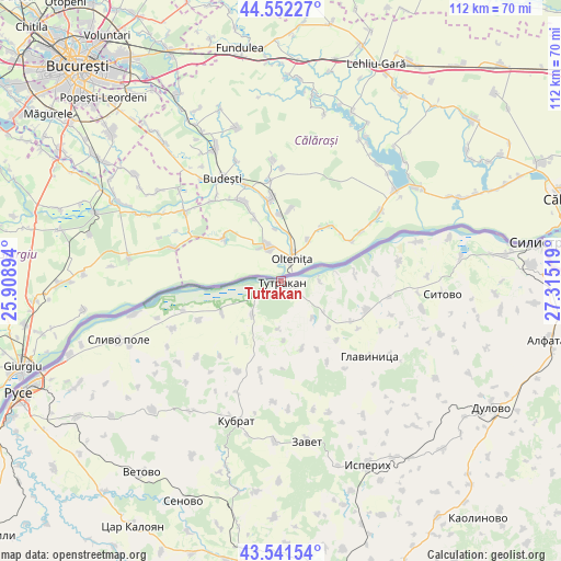
| Upper-left | 44.55227°, | 25.90894° |
| Center: | 44.04906°, | 26.61206° |
| Lower-right: | 43.54154°, | 27.31519° |
| Map W x H: | 112.4×112.4 km | = 69.8×69.8mi |
| max Lat: | 44.16214° ⇑1% North |
| Tutrakan: | 44.04906° |
| min Lat: | ⇓99% South 41.32715° |
| min Long | Tutrakan | max Long |
| 22.52139° | 26.61206° | 28.53429° |
| W 76.7%⇐ | ⇒23.3% E |
Elevation
Elevation of Tutrakan is 109 m = 358 ft, and this is 207.6 m = 681 ft below average elevation for this country.
| Max E: |
1221 m = 4006 ft | 77% |
| Avg. | 316.6 m = 1039 ft | |
| Tutrakan | 109 m = 358 ft | |
Min E: |
1 m = 3 ft | 23% |
See also: Bulgaria elevation on elevation.city.
Geographical zone
Tutrakan is located in North temperate zone (between Tropic of Cancer and the Arctic Circle). Distance of this Northern Tropic circle is 2291.9 km =1424.1 mi to South.| Distance of | km | miles | from Tutrakan |
|---|---|---|---|
| North Pole | 5109.3 | 3174.8 | to North |
| Arctic Circle | 2503.4 | 1555.5 | to North |
| Tropic Cancer | 2291.9 | 1424.1 | to South |
| Equator | 4897.8 | 3043.4 | to South |


Nearby cities:
15 places around Tutrakan: (largest is in red/bold)
• Alfatar
55.2 km =34.3 mi,  102°
102°
• Dulovo
50.2 km =31.2 mi,  120°
120°
• Glavinitsa
23 km =14.3 mi,  129°
129°
• Gorichevo
25.7 km =16 mi,  210°
210°
• Isperih
41 km =25.5 mi,  154°
154°
• Kubrat
29.5 km =18.3 mi,  197°
197°
• Medovene
32.3 km =20.1 mi,  193°
193°
• Senovo
48.5 km =30.1 mi, 203°
• Silistra
52.3 km =32.5 mi,  81°
81°
• Sitovo
32.7 km =20.3 mi,  94°
94°
• Slivo Pole
34.7 km =21.6 mi,  250°
250°
• Tochilari
25 km =15.5 mi, 207°
• Tsar Kaloyan
56.2 km =34.9 mi, 211°
• Vetovo
47.7 km =29.6 mi,  215°
215°
• Zavet
32.6 km =20.3 mi,  170°
170°
Sources, notices
• [Note1] Compared only with cities in Bulgaria existing in our database
• [Src1] Map data: © OpenStreetMap contributors (CC-BY-SA)
• [Src2] Other city data from geonames.org with taken over terms of usage.
• [Src3] Geographical zone / Annual Mean Temperature by Robert A. Rohde @ Wikipedia
