Kiten geodata
Kiten (Varna) is a populated place; located in Bulgaria in Europe/Sofia (GMT+3) time zone. With population of 1,115 people, there are 266 cities with bigger population in this country. Compared to other cities in Bulgaria, 59.7% of cities are located further ↓South; 86% of cities are located further ←West and 51% of cities have higher elevation than Kiten. Note1


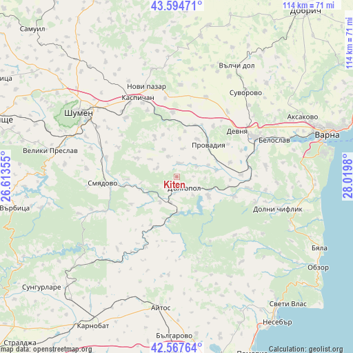
Kiten GPS coordinates[2]
43° 4' 59.988" North, 27° 19' 0.012" East
| Map corner | latitude | longitude |
|---|---|---|
| Upper-left | 43.59471°, | 26.61355° |
| Center: | 43.08333°, | 27.31667° |
| Lower-right: | 42.56764°, | 28.0198° |
| Map W x H: | 114.2×114.2 km | = 71×71mi |
| max Lat: | 44.16214° ⇑40.3% North |
| Kiten: | 43.08333° |
| min Lat: | ⇓59.7% South 41.32715° |
| min Long | Kiten | max Long |
| 22.52139° | 27.31667° | 28.53429° |
| W 86%⇐ | ⇒14% E |
Elevation
Elevation of Kiten is 219 m = 719 ft, and this is 97.6 m = 320 ft below average elevation for this country.
| Max E: |
1221 m = 4006 ft | 51% |
| Avg. | 316.6 m = 1039 ft | |
| Kiten | 219 m = 719 ft | |
Min E: |
1 m = 3 ft | 49% |
See also: Bulgaria elevation on elevation.city.
Geographical zone
Kiten is located in North temperate zone (between Tropic of Cancer and the Arctic Circle). Distance of this Northern Tropic circle is 2184.5 km =1357.4 mi to South.| Distance of | km | miles | from Kiten |
|---|---|---|---|
| North Pole | 5216.6 | 3241.4 | to North |
| Arctic Circle | 2610.8 | 1622.3 | to North |
| Tropic Cancer | 2184.5 | 1357.4 | to South |
| Equator | 4790.4 | 2976.6 | to South |


Nearby cities:
15 places around Kiten: (largest is in red/bold)
• Avren
28.7 km =17.8 mi,  82°
82°
• Beloslav
33.6 km =20.9 mi,  69°
69°
• Dalgopol
4.6 km =2.9 mi,  143°
143°
• Devnya
25.7 km =16 mi,  53°
53°
• Dolni Chiflik
34 km =21.1 mi,  107°
107°
• Kaspichan
28.7 km =17.8 mi,  334°
334°
• Novi Pazar
31.1 km =19.3 mi,  342°
342°
• Pliska
35.4 km =22 mi, 332°
• Provadia
14.6 km =9.1 mi,  40°
40°
• Ruen
31.6 km =19.6 mi,  184°
184°
• Shumen
38.1 km =23.7 mi,  303°
303°
• Smyadovo
24.4 km =15.2 mi,  265°
265°
• Suvorovo
35.8 km =22.2 mi, 39°
• Valchidol
40 km =24.9 mi,  28°
28°
• Vetrino
27.6 km =17.1 mi,  20°
20°
Sources, notices
• [Note1] Compared only with cities in Bulgaria existing in our database
• [Src1] Map data: © OpenStreetMap contributors (CC-BY-SA)
• [Src2] Other city data from geonames.org with taken over terms of usage.
• [Src3] Geographical zone / Annual Mean Temperature by Robert A. Rohde @ Wikipedia
