Dalgopol geodata
Dalgopol (Varna) is a populated place; located in Bulgaria in Europe/Sofia (GMT+3) time zone. With population of 5,272 people, there are 130 cities with bigger population in this country. Compared to other cities in Bulgaria, 57.7% of cities are located further ↓South; 86.3% of cities are located further ←West and 91.7% of cities have higher elevation than Dalgopol. Note1


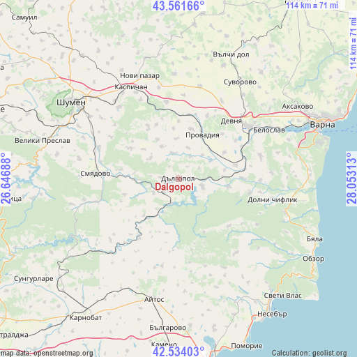
Dalgopol GPS coordinates[2]
43° 3' 0" North, 27° 21' 0" East
| Map corner | latitude | longitude |
|---|---|---|
| Upper-left | 43.56166°, | 26.64688° |
| Center: | 43.05°, | 27.35° |
| Lower-right: | 42.53403°, | 28.05313° |
| Map W x H: | 114.3×114.3 km | = 71×71mi |
| max Lat: | 44.16214° ⇑42.3% North |
| Dalgopol: | 43.05° |
| min Lat: | ⇓57.7% South 41.32715° |
| min Long | Dalgopol | max Long |
| 22.52139° | 27.35° | 28.53429° |
| W 86.3%⇐ | ⇒13.7% E |
Elevation
Elevation of Dalgopol is 34 m = 112 ft, and this is 282.6 m = 927 ft below average elevation for this country.
| Max E: |
1221 m = 4006 ft | 91.7% |
| Avg. | 316.6 m = 1039 ft | |
| Dalgopol | 34 m = 112 ft | |
Min E: |
1 m = 3 ft | 8.3% |
See also: Bulgaria elevation on elevation.city.
Geographical zone
Dalgopol is located in North temperate zone (between Tropic of Cancer and the Arctic Circle). Distance of this Northern Tropic circle is 2180.8 km =1355.1 mi to South.| Distance of | km | miles | from Dalgopol |
|---|---|---|---|
| North Pole | 5220.4 | 3243.8 | to North |
| Arctic Circle | 2614.5 | 1624.6 | to North |
| Tropic Cancer | 2180.8 | 1355.1 | to South |
| Equator | 4786.7 | 2974.3 | to South |


Nearby cities:
15 places around Dalgopol: (largest is in red/bold)
• Avren
26.8 km =16.7 mi,  73°
73°
• Aytos
39.8 km =24.7 mi,  191°
191°
• Bata
36.7 km =22.8 mi,  161°
161°
• Beloslav
32.7 km =20.3 mi,  61°
61°
• Devnya
26.1 km =16.2 mi,  42°
42°
• Dolni Chiflik
30.4 km =18.9 mi,  102°
102°
• Kaspichan
33.2 km =20.6 mi,  333°
333°
• Kiten
4.6 km =2.9 mi,  323°
323°
• Novi Pazar
35.5 km =22.1 mi,  339°
339°
• Pliska
40 km =24.9 mi, 331°
• Provadia
16.3 km =10.1 mi,  24°
24°
• Ruen
28.3 km =17.6 mi, 191°
• Smyadovo
27.1 km =16.8 mi,  273°
273°
• Suvorovo
37.2 km =23.1 mi,  32°
32°
• Vetrino
30.4 km =18.9 mi,  12°
12°
Sources, notices
• [Note1] Compared only with cities in Bulgaria existing in our database
• [Src1] Map data: © OpenStreetMap contributors (CC-BY-SA)
• [Src2] Other city data from geonames.org with taken over terms of usage.
• [Src3] Geographical zone / Annual Mean Temperature by Robert A. Rohde @ Wikipedia
