Smyadovo geodata
Smyadovo (Shumen) is a populated place; located in Bulgaria in Europe/Sofia (GMT+3) time zone. With population of 4,231 people, there are 150 cities with bigger population in this country. Compared to other cities in Bulgaria, 58.7% of cities are located further ↓South; 81.3% of cities are located further ←West and 82.3% of cities have higher elevation than Smyadovo. Note1


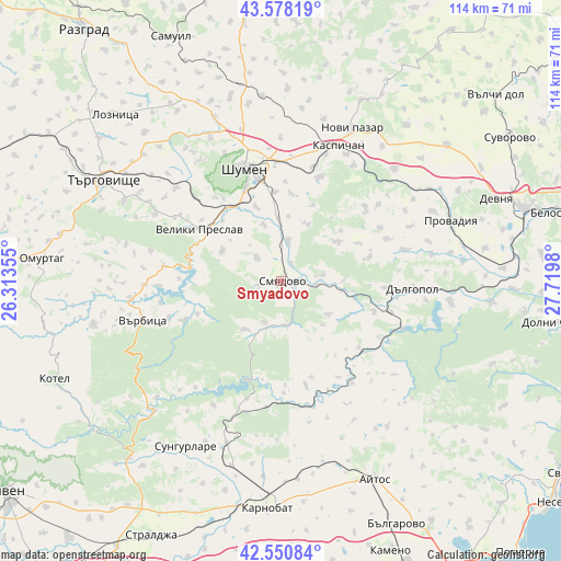
Smyadovo GPS coordinates[2]
43° 4' 0.012" North, 27° 1' 0.012" East
| Map corner | latitude | longitude |
|---|---|---|
| Upper-left | 43.57819°, | 26.31355° |
| Center: | 43.06667°, | 27.01667° |
| Lower-right: | 42.55084°, | 27.7198° |
| Map W x H: | 114.2×114.2 km | = 71×71mi |
| max Lat: | 44.16214° ⇑41.3% North |
| Smyadovo: | 43.06667° |
| min Lat: | ⇓58.7% South 41.32715° |
| min Long | Smyadovo | max Long |
| 22.52139° | 27.01667° | 28.53429° |
| W 81.3%⇐ | ⇒18.7% E |
Elevation
Elevation of Smyadovo is 86 m = 282 ft, and this is 230.6 m = 757 ft below average elevation for this country.
| Max E: |
1221 m = 4006 ft | 82.3% |
| Avg. | 316.6 m = 1039 ft | |
| Smyadovo | 86 m = 282 ft | |
Min E: |
1 m = 3 ft | 17.7% |
See also: Bulgaria elevation on elevation.city.
Geographical zone
Smyadovo is located in North temperate zone (between Tropic of Cancer and the Arctic Circle). Distance of this Northern Tropic circle is 2182.6 km =1356.2 mi to South.| Distance of | km | miles | from Smyadovo |
|---|---|---|---|
| North Pole | 5218.5 | 3242.6 | to North |
| Arctic Circle | 2612.6 | 1623.4 | to North |
| Tropic Cancer | 2182.6 | 1356.2 | to South |
| Equator | 4788.6 | 2975.5 | to South |


Nearby cities:
15 places around Smyadovo: (largest is in red/bold)
• Aytos
45 km =28 mi,  155°
155°
• Dalgopol
27.1 km =16.8 mi,  93°
93°
• Gara Hitrino
41.6 km =25.8 mi,  348°
348°
• Kaspichan
30.3 km =18.8 mi,  23°
23°
• Kiten
24.4 km =15.2 mi, 85°
• Novi Pazar
34.8 km =21.6 mi,  25°
25°
• Pliska
34.3 km =21.3 mi,  13°
13°
• Provadia
36.2 km =22.5 mi,  69°
69°
• Ruen
36.7 km =22.8 mi,  143°
143°
• Shumen
23.9 km =14.9 mi,  341°
341°
• Sungurlare
38.4 km =23.9 mi,  209°
209°
• Targovishte
41.5 km =25.8 mi,  299°
299°
• Varbitsa
32 km =19.9 mi,  256°
256°
• Veliki Preslav
19.7 km =12.2 mi, 304°
• Vetrino
43.7 km =27.2 mi,  50°
50°
Sources, notices
• [Note1] Compared only with cities in Bulgaria existing in our database
• [Src1] Map data: © OpenStreetMap contributors (CC-BY-SA)
• [Src2] Other city data from geonames.org with taken over terms of usage.
• [Src3] Geographical zone / Annual Mean Temperature by Robert A. Rohde @ Wikipedia
