Kaspichan geodata
Kaspichan (Shumen) is a seat of a third-order administrative division; located in Bulgaria in Europe/Sofia (GMT+3) time zone. With population of 3,635 people, there are 170 cities with bigger population in this country. Compared to other cities in Bulgaria, 70% of cities are located further ↓South; 83% of cities are located further ←West and 81% of cities have higher elevation than Kaspichan. Note1


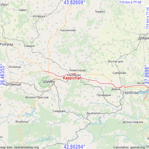
Kaspichan GPS coordinates[2]
43° 19' 0.012" North, 27° 10' 0.012" East
| Map corner | latitude | longitude |
|---|---|---|
| Upper-left | 43.82609°, | 26.46355° |
| Center: | 43.31667°, | 27.16667° |
| Lower-right: | 42.80294°, | 27.8698° |
| Map W x H: | 113.8×113.8 km | = 70.7×70.7mi |
| max Lat: | 44.16214° ⇑30% North |
| Kaspichan: | 43.31667° |
| min Lat: | ⇓70% South 41.32715° |
| min Long | Kaspichan | max Long |
| 22.52139° | 27.16667° | 28.53429° |
| W 83%⇐ | ⇒17% E |
Elevation
Elevation of Kaspichan is 95 m = 312 ft, and this is 221.6 m = 727 ft below average elevation for this country.
| Max E: |
1221 m = 4006 ft | 81% |
| Avg. | 316.6 m = 1039 ft | |
| Kaspichan | 95 m = 312 ft | |
Min E: |
1 m = 3 ft | 19% |
See also: Bulgaria elevation on elevation.city.
Geographical zone
Kaspichan is located in North temperate zone (between Tropic of Cancer and the Arctic Circle). Distance of this Northern Tropic circle is 2210.4 km =1373.5 mi to South.| Distance of | km | miles | from Kaspichan |
|---|---|---|---|
| North Pole | 5190.7 | 3225.4 | to North |
| Arctic Circle | 2584.8 | 1606.1 | to North |
| Tropic Cancer | 2210.4 | 1373.5 | to South |
| Equator | 4816.4 | 2992.8 | to South |


Nearby cities:
15 places around Kaspichan: (largest is in red/bold)
• Dalgopol
33.2 km =20.6 mi,  153°
153°
• Devnya
34.3 km =21.3 mi,  107°
107°
• Gara Hitrino
24 km =14.9 mi,  302°
302°
• Kaolinovo
33.6 km =20.9 mi,  353°
353°
• Kiten
28.7 km =17.8 mi, 154°
• Nikola-Kozlevo
28.3 km =17.6 mi,  10°
10°
• Novi Pazar
4.6 km =2.9 mi,  36°
36°
• Pliska
6.9 km =4.3 mi,  323°
323°
• Provadia
26.2 km =16.3 mi,  124°
124°
• Shumen
20.4 km =12.7 mi,  255°
255°
• Smyadovo
30.3 km =18.8 mi,  203°
203°
• Valchidol
32.3 km =20.1 mi,  73°
73°
• Veliki Preslav
32.9 km =20.4 mi,  239°
239°
• Venets
32.1 km =19.9 mi, 324°
• Vetrino
21.6 km =13.4 mi,  90°
90°
Sources, notices
• [Note1] Compared only with cities in Bulgaria existing in our database
• [Src1] Map data: © OpenStreetMap contributors (CC-BY-SA)
• [Src2] Other city data from geonames.org with taken over terms of usage.
• [Src3] Geographical zone / Annual Mean Temperature by Robert A. Rohde @ Wikipedia
