Slavyanovo geodata
Slavyanovo (Pleven) is a populated place; located in Bulgaria in Europe/Sofia (GMT+3) time zone. With population of 4,793 people, there are 139 cities with bigger population in this country. Compared to other cities in Bulgaria, 78.7% of cities are located further ↓South; 54.7% of cities are located further →East and 71% of cities have higher elevation than Slavyanovo. Note1


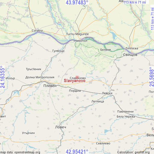
Slavyanovo GPS coordinates[2]
43° 28' 0.012" North, 24° 52' 0.012" East
| Map corner | latitude | longitude |
|---|---|---|
| Upper-left | 43.97483°, | 24.16355° |
| Center: | 43.46667°, | 24.86667° |
| Lower-right: | 42.95421°, | 25.5698° |
| Map W x H: | 113.5×113.5 km | = 70.5×70.5mi |
| max Lat: | 44.16214° ⇑21.3% North |
| Slavyanovo: | 43.46667° |
| min Lat: | ⇓78.7% South 41.32715° |
| min Long | Slavyanovo | max Long |
| 22.52139° | 24.86667° | 28.53429° |
| W 45.3%⇐ | ⇒54.7% E |
Elevation
Elevation of Slavyanovo is 135 m = 443 ft, and this is 181.6 m = 596 ft below average elevation for this country.
| Max E: |
1221 m = 4006 ft | 71% |
| Avg. | 316.6 m = 1039 ft | |
| Slavyanovo | 135 m = 443 ft | |
Min E: |
1 m = 3 ft | 29% |
See also: Bulgaria elevation on elevation.city.
Geographical zone
Slavyanovo is located in North temperate zone (between Tropic of Cancer and the Arctic Circle). Distance of this Northern Tropic circle is 2227.1 km =1383.9 mi to South.| Distance of | km | miles | from Slavyanovo |
|---|---|---|---|
| North Pole | 5174 | 3215 | to North |
| Arctic Circle | 2568.1 | 1595.7 | to North |
| Tropic Cancer | 2227.1 | 1383.9 | to South |
| Equator | 4833 | 3003.1 | to South |


Nearby cities:
15 places around Slavyanovo: (largest is in red/bold)
• Belene
28.9 km =18 mi,  46°
46°
• Byala Cherkva
45.9 km =28.5 mi,  130°
130°
• Dolna Mitropolia
26.9 km =16.7 mi,  270°
270°
• Dolni Dabnik
35.8 km =22.2 mi,  258°
258°
• Gulyantsi
23.9 km =14.9 mi,  324°
324°
• Iskar
40.4 km =25.1 mi,  304°
304°
• Letnitsa
24 km =14.9 mi,  135°
135°
• Levski
24.2 km =15 mi,  117°
117°
• Lovech
39 km =24.2 mi,  198°
198°
• Nikopol
26.6 km =16.5 mi,  4°
4°
• Pavlikeni
44.4 km =27.6 mi, 124°
• Pleven
20.9 km =13 mi,  254°
254°
• Pordim
9.4 km =5.8 mi,  188°
188°
• Suhindol
39.8 km =24.7 mi, 140°
• Svishtov
42.5 km =26.4 mi,  66°
66°
Sources, notices
• [Note1] Compared only with cities in Bulgaria existing in our database
• [Src1] Map data: © OpenStreetMap contributors (CC-BY-SA)
• [Src2] Other city data from geonames.org with taken over terms of usage.
• [Src3] Geographical zone / Annual Mean Temperature by Robert A. Rohde @ Wikipedia
