Gulyantsi geodata
Gulyantsi (Pleven) is a seat of a second-order administrative division; located in Bulgaria in Europe/Sofia (GMT+3) time zone. With population of 3,589 people, there are 171 cities with bigger population in this country. Compared to other cities in Bulgaria, 86.3% of cities are located further ↓South; 58.3% of cities are located further →East and 90% of cities have higher elevation than Gulyantsi. Note1


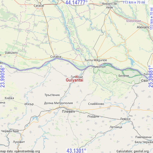
Gulyantsi GPS coordinates[2]
43° 38' 27.924" North, 24° 41' 37.248" East
| Map corner | latitude | longitude |
|---|---|---|
| Upper-left | 44.14777°, | 23.99056° |
| Center: | 43.64109°, | 24.69368° |
| Lower-right: | 43.1301°, | 25.39681° |
| Map W x H: | 113.2×113.2 km | = 70.3×70.3mi |
| max Lat: | 44.16214° ⇑13.7% North |
| Gulyantsi: | 43.64109° |
| min Lat: | ⇓86.3% South 41.32715° |
| min Long | Gulyantsi | max Long |
| 22.52139° | 24.69368° | 28.53429° |
| W 41.7%⇐ | ⇒58.3% E |
Elevation
Elevation of Gulyantsi is 37 m = 121 ft, and this is 279.6 m = 917 ft below average elevation for this country.
| Max E: |
1221 m = 4006 ft | 90% |
| Avg. | 316.6 m = 1039 ft | |
| Gulyantsi | 37 m = 121 ft | |
Min E: |
1 m = 3 ft | 10% |
See also: Bulgaria elevation on elevation.city.
Geographical zone
Gulyantsi is located in North temperate zone (between Tropic of Cancer and the Arctic Circle). Distance of this Northern Tropic circle is 2246.5 km =1395.9 mi to South.| Distance of | km | miles | from Gulyantsi |
|---|---|---|---|
| North Pole | 5154.6 | 3202.9 | to North |
| Arctic Circle | 2548.7 | 1583.7 | to North |
| Tropic Cancer | 2246.5 | 1395.9 | to South |
| Equator | 4852.4 | 3015.1 | to South |


Nearby cities:
15 places around Gulyantsi: (largest is in red/bold)
• Belene
34.8 km =21.6 mi,  89°
89°
• Dolna Mitropolia
23.3 km =14.5 mi,  213°
213°
• Dolni Dabnik
34 km =21.1 mi,  218°
218°
• Iskar
19.7 km =12.2 mi,  279°
279°
• Iskar
40.4 km =25.1 mi,  238°
238°
• Knezha
51.6 km =32.1 mi,  252°
252°
• Koynare
55.6 km =34.5 mi,  234°
234°
• Letnitsa
47.7 km =29.6 mi,  140°
140°
• Levski
46.8 km =29.1 mi,  130°
130°
• Lovech
56.5 km =35.1 mi,  178°
178°
• Nikopol
17.7 km =11 mi,  66°
66°
• Pleven
25.7 km =16 mi,  193°
193°
• Pordim
31.3 km =19.4 mi,  156°
156°
• Slavyanovo
23.9 km =14.9 mi, 144°
• Svishtov
52.9 km =32.9 mi, 92°
Sources, notices
• [Note1] Compared only with cities in Bulgaria existing in our database
• [Src1] Map data: © OpenStreetMap contributors (CC-BY-SA)
• [Src2] Other city data from geonames.org with taken over terms of usage.
• [Src3] Geographical zone / Annual Mean Temperature by Robert A. Rohde @ Wikipedia
