Kazanlak geodata
Kazanlak (Stara Zagora) is a populated place; located in Bulgaria in Europe/Sofia (GMT+3) time zone. With population of 55,196 people, there are 18 cities with bigger population in this country. Compared to other cities in Bulgaria, 61.7% of cities are located further ↑North; 57% of cities are located further ←West and 67.7% of cities have lower elevation than Kazanlak. Note1


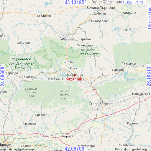
Kazanlak GPS coordinates[2]
42° 37' 0.012" North, 25° 24' 0" East
| Map corner | latitude | longitude |
|---|---|---|
| Upper-left | 43.13195°, | 24.69688° |
| Center: | 42.61667°, | 25.4° |
| Lower-right: | 42.09709°, | 26.10313° |
| Map W x H: | 115.1×115.1 km | = 71.5×71.5mi |
| max Lat: | 44.16214° ⇑61.7% North |
| Kazanlak: | 42.61667° |
| min Lat: | ⇓38.3% South 41.32715° |
| min Long | Kazanlak | max Long |
| 22.52139° | 25.4° | 28.53429° |
| W 57%⇐ | ⇒43% E |
Elevation
Elevation of Kazanlak is 366 m = 1201 ft, and this is 49.4 m = 162 ft above average elevation for this country.
| Max E: |
1221 m = 4006 ft | 32.3% |
| Kazanlak | 366 m 1201 ft | |
| Avg. | 316.6 m = 1039 ft | |
Min E: |
1 m = 3 ft | 67.7% |
See also: Kazanlak elevation on elevation.city.
Geographical zone
Kazanlak is located in North temperate zone (between Tropic of Cancer and the Arctic Circle). Distance of this Northern Tropic circle is 2132.6 km =1325.1 mi to South.| Distance of | km | miles | from Kazanlak |
|---|---|---|---|
| North Pole | 5268.5 | 3273.7 | to North |
| Arctic Circle | 2662.6 | 1654.5 | to North |
| Tropic Cancer | 2132.6 | 1325.1 | to South |
| Equator | 4738.5 | 2944.4 | to South |


Nearby cities:
15 places around Kazanlak: (largest is in red/bold)
• Asen
16.8 km =10.4 mi,  282°
282°
• Bratya Daskalovi
38.3 km =23.8 mi,  203°
203°
• Brezovo
39.4 km =24.5 mi,  221°
221°
• Dryanovo
40.8 km =25.4 mi,  9°
9°
• Elkhovo
26.1 km =16.2 mi,  173°
173°
• Gabrovo
29.2 km =18.1 mi,  349°
349°
• Gurkovo
33.2 km =20.6 mi,  80°
80°
• Kalofer
34.1 km =21.2 mi,  270°
270°
• Maglizh
12.4 km =7.7 mi,  98°
98°
• Nikolaevo
32.8 km =20.4 mi,  86°
86°
• Pavel Banya
16.5 km =10.3 mi,  263°
263°
• Shipka
12.4 km =7.7 mi,  333°
333°
• Stara Zagora
28.5 km =17.7 mi,  135°
135°
• Tryavna
29 km =18 mi,  16°
16°
• Zelenikovo
35.4 km =22 mi,  227°
227°
Sources, notices
• [Note1] Compared only with cities in Bulgaria existing in our database
• [Src1] Map data: © OpenStreetMap contributors (CC-BY-SA)
• [Src2] Other city data from geonames.org with taken over terms of usage.
• [Src3] Geographical zone / Annual Mean Temperature by Robert A. Rohde @ Wikipedia
