Batak geodata
Batak (Pazardzhik) is a seat of a second-order administrative division; located in Bulgaria in Europe/Sofia (GMT+3) time zone. With population of 3,917 people, there are 157 cities with bigger population in this country. Compared to other cities in Bulgaria, 86.3% of cities are located further ↑North; 66% of cities are located further →East and 98% of cities have lower elevation than Batak. Note1


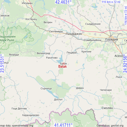
Batak GPS coordinates[2]
41° 56' 32.1" North, 24° 13' 6.348" East
| Map corner | latitude | longitude |
|---|---|---|
| Upper-left | 42.4631°, | 23.51531° |
| Center: | 41.94225°, | 24.21843° |
| Lower-right: | 41.41711°, | 24.92156° |
| Map W x H: | 116.3×116.3 km | = 72.3×72.3mi |
| max Lat: | 44.16214° ⇑86.3% North |
| Batak: | 41.94225° |
| min Lat: | ⇓13.7% South 41.32715° |
| min Long | Batak | max Long |
| 22.52139° | 24.21843° | 28.53429° |
| W 34%⇐ | ⇒66% E |
Elevation
Elevation of Batak is 1037 m = 3402 ft, and this is 720.4 m = 2364 ft above average elevation for this country.
| Max E: |
1221 m = 4006 ft | 2% |
| Batak | 1037 m 3402 ft | |
| Avg. | 316.6 m = 1039 ft | |
Min E: |
1 m = 3 ft | 98% |
See also: Bulgaria elevation on elevation.city.
Geographical zone
Batak is located in North temperate zone (between Tropic of Cancer and the Arctic Circle). Distance of this Northern Tropic circle is 2057.6 km =1278.5 mi to South.| Distance of | km | miles | from Batak |
|---|---|---|---|
| North Pole | 5343.5 | 3320.3 | to North |
| Arctic Circle | 2737.6 | 1701.1 | to North |
| Tropic Cancer | 2057.6 | 1278.5 | to South |
| Equator | 4663.5 | 2897.8 | to South |


Nearby cities:
15 places around Batak: (largest is in red/bold)
• Belovo
34.2 km =21.3 mi,  331°
331°
• Borino
29.4 km =18.3 mi,  167°
167°
• Bratsigovo
14.8 km =9.2 mi,  55°
55°
• Devin
26.8 km =16.7 mi,  145°
145°
• Dospat
33.5 km =20.8 mi,  188°
188°
• Gyovren
33.6 km =20.9 mi,  157°
157°
• Krichim
23.8 km =14.8 mi, 59°
• Pazardzhik
30.2 km =18.8 mi,  18°
18°
• Perushtitsa
29.9 km =18.6 mi,  66°
66°
• Peshtera
12.2 km =7.6 mi,  33°
33°
• Rakitovo
12.1 km =7.5 mi,  296°
296°
• Sarnitsa
27.8 km =17.3 mi,  215°
215°
• Septemvri
30.8 km =19.1 mi,  346°
346°
• Stamboliyski
33.6 km =20.9 mi,  50°
50°
• Velingrad
21 km =13 mi, 296°
Sources, notices
• [Note1] Compared only with cities in Bulgaria existing in our database
• [Src1] Map data: © OpenStreetMap contributors (CC-BY-SA)
• [Src2] Other city data from geonames.org with taken over terms of usage.
• [Src3] Geographical zone / Annual Mean Temperature by Robert A. Rohde @ Wikipedia
