Perushtitsa geodata
Perushtitsa (Plovdiv) is a populated place; located in Bulgaria in Europe/Sofia (GMT+3) time zone. With population of 5,350 people, there are 129 cities with bigger population in this country. Compared to other cities in Bulgaria, 82.7% of cities are located further ↑North; 59.7% of cities are located further →East and 70.7% of cities have lower elevation than Perushtitsa. Note1


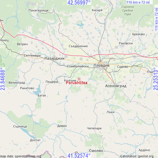
Perushtitsa GPS coordinates[2]
42° 3' 0" North, 24° 33' 0" East
| Map corner | latitude | longitude |
|---|---|---|
| Upper-left | 42.56997°, | 23.84688° |
| Center: | 42.05°, | 24.55° |
| Lower-right: | 41.52574°, | 25.25313° |
| Map W x H: | 116.1×116.1 km | = 72.1×72.1mi |
| max Lat: | 44.16214° ⇑82.7% North |
| Perushtitsa: | 42.05° |
| min Lat: | ⇓17.3% South 41.32715° |
| min Long | Perushtitsa | max Long |
| 22.52139° | 24.55° | 28.53429° |
| W 40.3%⇐ | ⇒59.7% E |
Elevation
Elevation of Perushtitsa is 407 m = 1335 ft, and this is 90.4 m = 297 ft above average elevation for this country.
| Max E: |
1221 m = 4006 ft | 29.3% |
| Perushtitsa | 407 m 1335 ft | |
| Avg. | 316.6 m = 1039 ft | |
Min E: |
1 m = 3 ft | 70.7% |
See also: Bulgaria elevation on elevation.city.
Geographical zone
Perushtitsa is located in North temperate zone (between Tropic of Cancer and the Arctic Circle). Distance of this Northern Tropic circle is 2069.6 km =1286 mi to South.| Distance of | km | miles | from Perushtitsa |
|---|---|---|---|
| North Pole | 5331.5 | 3312.8 | to North |
| Arctic Circle | 2725.7 | 1693.7 | to North |
| Tropic Cancer | 2069.6 | 1286 | to South |
| Equator | 4675.5 | 2905.2 | to South |


Nearby cities:
15 places around Perushtitsa: (largest is in red/bold)
• Asenovgrad
26.4 km =16.4 mi,  98°
98°
• Batak
29.9 km =18.6 mi,  246°
246°
• Bratsigovo
15.6 km =9.7 mi,  256°
256°
• Chepelare
36.9 km =22.9 mi,  162°
162°
• Devin
36.3 km =22.6 mi,  199°
199°
• Kaloyanovo
36.6 km =22.7 mi,  24°
24°
• Krichim
6.9 km =4.3 mi,  270°
270°
• Laki
31.3 km =19.4 mi,  135°
135°
• Pazardzhik
24.4 km =15.2 mi,  313°
313°
• Peshtera
20.7 km =12.9 mi, 264°
• Plovdiv
19.9 km =12.4 mi,  56°
56°
• Rakitovo
38.8 km =24.1 mi, 260°
• Sadovo
33.4 km =20.8 mi,  74°
74°
• Saedinenie
24.1 km =15 mi,  0°
0°
• Stamboliyski
9.4 km =5.8 mi,  351°
351°
Sources, notices
• [Note1] Compared only with cities in Bulgaria existing in our database
• [Src1] Map data: © OpenStreetMap contributors (CC-BY-SA)
• [Src2] Other city data from geonames.org with taken over terms of usage.
• [Src3] Geographical zone / Annual Mean Temperature by Robert A. Rohde @ Wikipedia
