Velingrad geodata
Velingrad (Pazardzhik) is a seat of a second-order administrative division; located in Bulgaria in Europe/Sofia (GMT+3) time zone. With population of 24,036 people, there are 40 cities with bigger population in this country. Compared to other cities in Bulgaria, 83.7% of cities are located further ↑North; 72% of cities are located further →East and 92.7% of cities have lower elevation than Velingrad. Note1


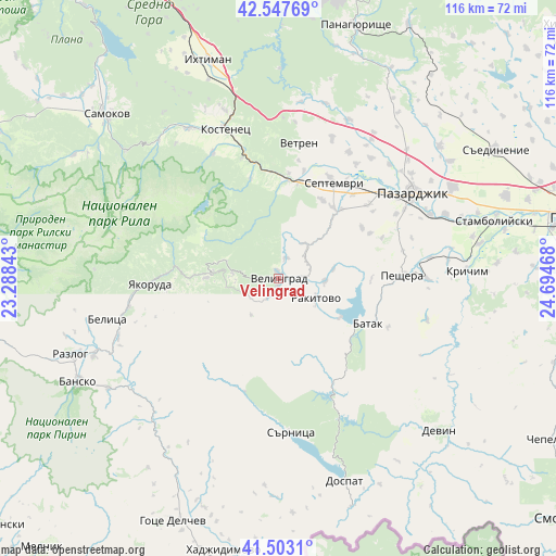
Velingrad GPS coordinates[2]
42° 1' 39.144" North, 23° 59' 29.58" East
| Map corner | latitude | longitude |
|---|---|---|
| Upper-left | 42.54769°, | 23.28843° |
| Center: | 42.02754°, | 23.99155° |
| Lower-right: | 41.5031°, | 24.69468° |
| Map W x H: | 116.1×116.1 km | = 72.1×72.1mi |
| max Lat: | 44.16214° ⇑83.7% North |
| Velingrad: | 42.02754° |
| min Lat: | ⇓16.3% South 41.32715° |
| min Long | Velingrad | max Long |
| 22.52139° | 23.99155° | 28.53429° |
| W 28%⇐ | ⇒72% E |
Elevation
Elevation of Velingrad is 750 m = 2461 ft, and this is 433.4 m = 1422 ft above average elevation for this country.
| Max E: |
1221 m = 4006 ft | 7.3% |
| Velingrad | 750 m 2461 ft | |
| Avg. | 316.6 m = 1039 ft | |
Min E: |
1 m = 3 ft | 92.7% |
See also: Bulgaria elevation on elevation.city.
Geographical zone
Velingrad is located in North temperate zone (between Tropic of Cancer and the Arctic Circle). Distance of this Northern Tropic circle is 2067.1 km =1284.4 mi to South.| Distance of | km | miles | from Velingrad |
|---|---|---|---|
| North Pole | 5334 | 3314.4 | to North |
| Arctic Circle | 2728.1 | 1695.2 | to North |
| Tropic Cancer | 2067.1 | 1284.4 | to South |
| Equator | 4673 | 2903.7 | to South |


Nearby cities:
15 places around Velingrad: (largest is in red/bold)
• Batak
21 km =13 mi,  116°
116°
• Belitsa
35.5 km =22.1 mi,  257°
257°
• Belovo
20.7 km =12.9 mi,  6°
6°
• Borino
45.6 km =28.3 mi,  146°
146°
• Bratsigovo
31 km =19.3 mi,  92°
92°
• Dolna Banya
35.5 km =22.1 mi,  328°
328°
• Dospat
44.8 km =27.8 mi,  161°
161°
• Krichim
39.3 km =24.4 mi, 86°
• Lesichovo
37.9 km =23.5 mi,  15°
15°
• Pazardzhik
34.1 km =21.2 mi,  55°
55°
• Peshtera
25.5 km =15.8 mi, 88°
• Rakitovo
8.9 km =5.5 mi, 117°
• Sarnitsa
32.3 km =20.1 mi,  175°
175°
• Septemvri
23.4 km =14.5 mi,  29°
29°
• Yakoruda
25.4 km =15.8 mi,  269°
269°
Sources, notices
• [Note1] Compared only with cities in Bulgaria existing in our database
• [Src1] Map data: © OpenStreetMap contributors (CC-BY-SA)
• [Src2] Other city data from geonames.org with taken over terms of usage.
• [Src3] Geographical zone / Annual Mean Temperature by Robert A. Rohde @ Wikipedia
