Zagnanado geodata
Zagnanado (Zou) is a seat of a third-order administrative division; located in Benin in Africa/Porto-Novo (GMT+1) time zone. In our database, there are 34 cities with bigger population. Compared to other cities in Benin, 56.5% of cities are located further ↓South; 56.5% of cities are located further ←West and 54.3% of cities have higher elevation than Zagnanado. Note1


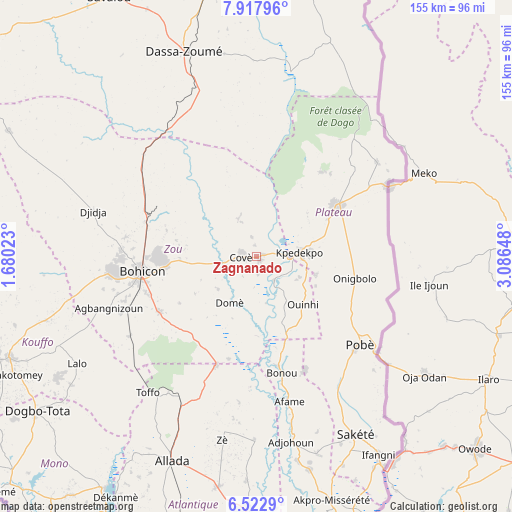
Zagnanado GPS coordinates[2]
7° 13' 15.492" North, 2° 23' 0.06" East
| Map corner | latitude | longitude |
|---|---|---|
| Upper-left | 7.91796°, | 1.68023° |
| Center: | 7.22097°, | 2.38335° |
| Lower-right: | 6.5229°, | 3.08648° |
| Map W x H: | 155.1×155.1 km | = 96.4×96.4mi |
| max Lat: | 11.86819° ⇑43.5% North |
| Zagnanado: | 7.22097° |
| min Lat: | ⇓56.5% South 6.28036° |
| min Long | Zagnanado | max Long |
| 1.26651° | 2.38335° | 3.38327° |
| W 56.5%⇐ | ⇒43.5% E |
Elevation
Elevation of Zagnanado is 108 m = 354 ft, and this is 54.8 m = 180 ft below average elevation for this country.
| Max E: |
472 m = 1549 ft | 54.3% |
| Avg. | 162.8 m = 534 ft | |
| Zagnanado | 108 m = 354 ft | |
Min E: |
1 m = 3 ft | 45.7% |
See also: Benin elevation on elevation.city.
Geographical zone
Zagnanado is located in North Torrid zone (between Equator and Tropic of Cancer). Distance of Equator is 802.9 km =498.9 mi to South.| Distance of | km | miles | from Zagnanado |
|---|---|---|---|
| North Pole | 9204.2 | 5719.2 | to North |
| Arctic Circle | 6598.3 | 4100 | to North |
| Tropic Cancer | 1803 | 1120.3 | to North |
| Equator | 802.9 | 498.9 | to South |


Nearby cities:
15 places around Zagnanado: (largest is in red/bold)
• Abomey
43.5 km =27 mi,  264°
264°
• Adjohon
56.8 km =35.3 mi,  169°
169°
• Allada
66.9 km =41.6 mi,  202°
202°
• Avakpa
72.6 km =45.1 mi,  211°
211°
• Banigbé
73.1 km =45.4 mi,  150°
150°
• Bohicon
35.3 km =21.9 mi, 262°
• Cové
4.8 km =3 mi,  270°
270°
• Dassa-Zoumé
62.8 km =39 mi,  339°
339°
• Hinvi
55.9 km =34.7 mi, 205°
• Houinvigue
38.7 km =24 mi,  163°
163°
• Kétou
28.6 km =17.8 mi,  56°
56°
• Ouinhi
18.8 km =11.7 mi,  144°
144°
• Pobé
41 km =25.5 mi,  130°
130°
• Sakété
61.9 km =38.5 mi, 150°
• Sé
60.4 km =37.5 mi, 210°
Sources, notices
• [Note1] Compared only with cities in Benin existing in our database
• [Src1] Map data: © OpenStreetMap contributors (CC-BY-SA)
• [Src2] Other city data from geonames.org with taken over terms of usage.
• [Src3] Geographical zone / Annual Mean Temperature by Robert A. Rohde @ Wikipedia
