Sakété geodata
Sakété (Plateau) is a seat of a first-order administrative division; located in Benin in Africa/Porto-Novo (GMT+1) time zone. With population of 30,111 people, there are 18 cities with bigger population in this country. Compared to other cities in Benin, 65.2% of cities are located further ↑North; 84.8% of cities are located further ←West and 60.9% of cities have higher elevation than Sakété. Note1


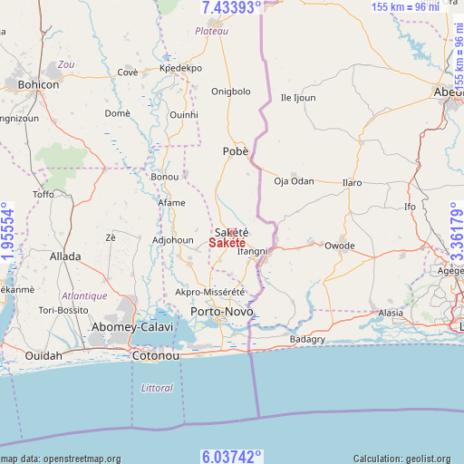
Sakété GPS coordinates[2]
6° 44' 10.248" North, 2° 39' 31.176" East
| Map corner | latitude | longitude |
|---|---|---|
| Upper-left | 7.43393°, | 1.95554° |
| Center: | 6.73618°, | 2.65866° |
| Lower-right: | 6.03742°, | 3.36179° |
| Map W x H: | 155.3×155.3 km | = 96.5×96.5mi |
| max Lat: | 11.86819° ⇑65.2% North |
| Sakété: | 6.73618° |
| min Lat: | ⇓34.8% South 6.28036° |
| min Long | Sakété | max Long |
| 1.26651° | 2.65866° | 3.38327° |
| W 84.8%⇐ | ⇒15.2% E |
Elevation
Elevation of Sakété is 80 m = 262 ft, and this is 82.8 m = 272 ft below average elevation for this country.
| Max E: |
472 m = 1549 ft | 60.9% |
| Avg. | 162.8 m = 534 ft | |
| Sakété | 80 m = 262 ft | |
Min E: |
1 m = 3 ft | 39.1% |
See also: Benin elevation on elevation.city.
Geographical zone
Sakété is located in North Torrid zone (between Equator and Tropic of Cancer). Distance of Equator is 749 km =465.4 mi to South.| Distance of | km | miles | from Sakété |
|---|---|---|---|
| North Pole | 9258.1 | 5752.7 | to North |
| Arctic Circle | 6652.2 | 4133.5 | to North |
| Tropic Cancer | 1856.9 | 1153.8 | to North |
| Equator | 749 | 465.4 | to South |


Nearby cities:
15 places around Sakété: (largest is in red/bold)
• Abomey-Calavi
46.3 km =28.8 mi,  226°
226°
• Adjohon
20.1 km =12.5 mi,  264°
264°
• Allada
56.6 km =35.2 mi, 262°
• Banigbé
11.2 km =7 mi,  151°
151°
• Cotonou
49 km =30.4 mi,  212°
212°
• Hinvi
54.4 km =33.8 mi,  273°
273°
• Houinvigue
25.8 km =16 mi,  310°
310°
• Hévié
57.4 km =35.7 mi, 231°
• Ouinhi
43.3 km =26.9 mi,  333°
333°
• Pobé
27.1 km =16.8 mi,  1°
1°
• Porto-Novo
27.3 km =17 mi,  192°
192°
• Semi
41.3 km =25.7 mi, 186°
• So-Ava
39.2 km =24.4 mi, 226°
• Sé
61.3 km =38.1 mi, 271°
• Zagnanado
61.9 km =38.5 mi, 330°
Sources, notices
• [Note1] Compared only with cities in Benin existing in our database
• [Src1] Map data: © OpenStreetMap contributors (CC-BY-SA)
• [Src2] Other city data from geonames.org with taken over terms of usage.
• [Src3] Geographical zone / Annual Mean Temperature by Robert A. Rohde @ Wikipedia
