Abomey geodata
Abomey (Zou) is a seat of a first-order administrative division; located in Benin in Africa/Porto-Novo (GMT+1) time zone. With population of 82,154 people, there are 9 cities with bigger population in this country. Compared to other cities in Benin, 54.3% of cities are located further ↓South; 76.1% of cities are located further →East and 69.6% of cities have lower elevation than Abomey. Note1


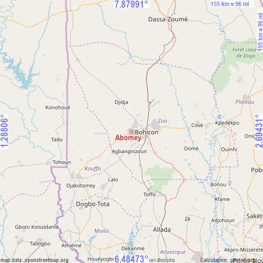
Abomey GPS coordinates[2]
7° 10' 58.296" North, 1° 59' 28.284" East
| Map corner | latitude | longitude |
|---|---|---|
| Upper-left | 7.87991°, | 1.28806° |
| Center: | 7.18286°, | 1.99119° |
| Lower-right: | 6.48473°, | 2.69431° |
| Map W x H: | 155.1×155.1 km | = 96.4×96.4mi |
| max Lat: | 11.86819° ⇑45.7% North |
| Abomey: | 7.18286° |
| min Lat: | ⇓54.3% South 6.28036° |
| min Long | Abomey | max Long |
| 1.26651° | 1.99119° | 3.38327° |
| W 23.9%⇐ | ⇒76.1% E |
Elevation
Elevation of Abomey is 228 m = 748 ft, and this is 65.2 m = 214 ft above average elevation for this country.
| Max E: |
472 m = 1549 ft | 30.4% |
| Abomey | 228 m 748 ft | |
| Avg. | 162.8 m = 534 ft | |
Min E: |
1 m = 3 ft | 69.6% |
See also: Abomey elevation on elevation.city.
Geographical zone
Abomey is located in North Torrid zone (between Equator and Tropic of Cancer). Distance of Equator is 798.7 km =496.3 mi to South.| Distance of | km | miles | from Abomey |
|---|---|---|---|
| North Pole | 9208.4 | 5721.8 | to North |
| Arctic Circle | 6602.5 | 4102.6 | to North |
| Tropic Cancer | 1807.3 | 1123 | to North |
| Equator | 798.7 | 496.3 | to South |


Nearby cities:
15 places around Abomey: (largest is in red/bold)
• Adjohon
74.5 km =46.3 mi,  133°
133°
• Allada
60.2 km =37.4 mi,  162°
162°
• Aplahoué
43.9 km =27.3 mi,  230°
230°
• Avakpa
58.1 km =36.1 mi,  174°
174°
• Bohicon
8.3 km =5.2 mi,  93°
93°
• Cové
38.7 km =24 mi,  83°
83°
• Dassa-Zoumé
66.5 km =41.3 mi,  18°
18°
• Dogbo
48.6 km =30.2 mi,  208°
208°
• Hinvi
50.2 km =31.2 mi, 157°
• Houinvigue
63.3 km =39.3 mi,  121°
121°
• Kétou
70.1 km =43.6 mi,  73°
73°
• Lokossa
67.7 km =42.1 mi, 206°
• Ouinhi
55.4 km =34.4 mi,  101°
101°
• Sé
49.3 km =30.6 mi, 165°
• Zagnanado
43.5 km =27 mi, 84°
Sources, notices
• [Note1] Compared only with cities in Benin existing in our database
• [Src1] Map data: © OpenStreetMap contributors (CC-BY-SA)
• [Src2] Other city data from geonames.org with taken over terms of usage.
• [Src3] Geographical zone / Annual Mean Temperature by Robert A. Rohde @ Wikipedia
