Avakpa geodata
Avakpa (Atlantique) is a seat of a third-order administrative division; located in Benin in Africa/Porto-Novo (GMT+1) time zone. In our database, there are 34 cities with bigger population. Compared to other cities in Benin, 71.7% of cities are located further ↑North; 71.7% of cities are located further →East and 69.6% of cities have higher elevation than Avakpa. Note1


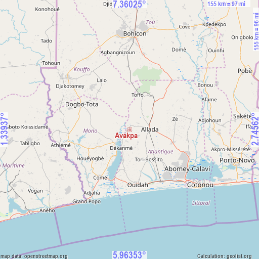
Avakpa GPS coordinates[2]
6° 39' 44.604" North, 2° 2' 32.964" East
| Map corner | latitude | longitude |
|---|---|---|
| Upper-left | 7.36025°, | 1.33937° |
| Center: | 6.66239°, | 2.04249° |
| Lower-right: | 5.96353°, | 2.74562° |
| Map W x H: | 155.3×155.3 km | = 96.5×96.5mi |
| max Lat: | 11.86819° ⇑71.7% North |
| Avakpa: | 6.66239° |
| min Lat: | ⇓28.3% South 6.28036° |
| min Long | Avakpa | max Long |
| 1.26651° | 2.04249° | 3.38327° |
| W 28.3%⇐ | ⇒71.7% E |
Elevation
Elevation of Avakpa is 54 m = 177 ft, and this is 108.8 m = 357 ft below average elevation for this country.
| Max E: |
472 m = 1549 ft | 69.6% |
| Avg. | 162.8 m = 534 ft | |
| Avakpa | 54 m = 177 ft | |
Min E: |
1 m = 3 ft | 30.4% |
See also: Benin elevation on elevation.city.
Geographical zone
Avakpa is located in North Torrid zone (between Equator and Tropic of Cancer). Distance of Equator is 740.8 km =460.3 mi to South.| Distance of | km | miles | from Avakpa |
|---|---|---|---|
| North Pole | 9266.3 | 5757.8 | to North |
| Arctic Circle | 6660.4 | 4138.6 | to North |
| Tropic Cancer | 1865.1 | 1158.9 | to North |
| Equator | 740.8 | 460.3 | to South |


Nearby cities:
15 places around Avakpa: (largest is in red/bold)
• Abomey-Calavi
42 km =26.1 mi,  124°
124°
• Adjohon
48.5 km =30.1 mi,  82°
82°
• Allada
12 km =7.5 mi,  88°
88°
• Aplahoué
49.8 km =30.9 mi,  307°
307°
• Comé
33.4 km =20.8 mi,  212°
212°
• Dogbo
32.7 km =20.3 mi,  297°
297°
• Grand-Popo
48.9 km =30.4 mi, 209°
• Hinvi
18 km =11.2 mi,  49°
49°
• Hévié
35.7 km =22.2 mi,  140°
140°
• Kpomassè
22.9 km =14.2 mi,  193°
193°
• Lokossa
36.1 km =22.4 mi,  265°
265°
• Ouidah
33.6 km =20.9 mi,  171°
171°
• Pahou
36 km =22.4 mi,  148°
148°
• So-Ava
44 km =27.3 mi, 115°
• Sé
12.2 km =7.6 mi,  33°
33°
Sources, notices
• [Note1] Compared only with cities in Benin existing in our database
• [Src1] Map data: © OpenStreetMap contributors (CC-BY-SA)
• [Src2] Other city data from geonames.org with taken over terms of usage.
• [Src3] Geographical zone / Annual Mean Temperature by Robert A. Rohde @ Wikipedia
