Kuala Belait geodata
Kuala Belait (Belait) is a seat of a first-order administrative division; located in Brunei in Asia/Brunei (GMT+8) time zone. With population of 31,178 people, there is 1 city with bigger population in this country. Compared to other cities in Brunei, 100% of cities are located further ↑North; 100% of cities are located further →East and 50% of cities have lower elevation than Kuala Belait. Note1


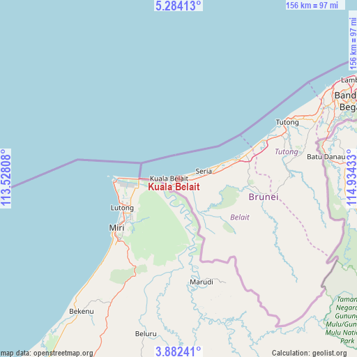
Kuala Belait GPS coordinates[2]
4° 35' 0.996" North, 114° 13' 52.32" East
| Map corner | latitude | longitude |
|---|---|---|
| Upper-left | 5.28413°, | 113.52808° |
| Center: | 4.58361°, | 114.2312° |
| Lower-right: | 3.88241°, | 114.93433° |
| Map W x H: | 155.9×155.9 km | = 96.9×96.9mi |
| max Lat: | 5.02447° ⇑100% North |
| Kuala Belait: | 4.58361° |
| min Lat: | ⇓0% South 4.58361° |
| min Long | Kuala Belait | max Long |
| 114.2312° | 114.2312° | 115.07167° |
| W 0%⇐ | ⇒100% E |
Elevation
Elevation of Kuala Belait is 5 m = 16 ft, and this is 9.1 m = 30 ft below average elevation for this country.
| Max E: |
75 m = 246 ft | 50% |
| Avg. | 14.1 m = 46 ft | |
| Kuala Belait | 5 m = 16 ft | |
Min E: |
1 m = 3 ft | 50% |
See also: Brunei elevation on elevation.city.
Geographical zone
Kuala Belait is located in North Torrid zone (between Equator and Tropic of Cancer). Distance of Equator is 509.6 km =316.7 mi to South.| Distance of | km | miles | from Kuala Belait |
|---|---|---|---|
| North Pole | 9497.4 | 5901.4 | to North |
| Arctic Circle | 6891.5 | 4282.2 | to North |
| Tropic Cancer | 2096.3 | 1302.6 | to North |
| Equator | 509.6 | 316.7 | to South |


Nearby cities:
6 places around Kuala Belait: (largest is in red/bold)
• Bandar Seri Begawan
85.6 km =53.2 mi,  66°
66°
• Bangar
94.2 km =58.5 mi,  81°
81°
• Kapok
102.8 km =63.9 mi,  61°
61°
• Mentiri
97.5 km =60.6 mi, 63°
• Seria
10.7 km =6.6 mi, 76°
• Tutong
52.3 km =32.5 mi, 62°
Sources, notices
• [Note1] Compared only with cities in Brunei existing in our database
• [Src1] Map data: © OpenStreetMap contributors (CC-BY-SA)
• [Src2] Other city data from geonames.org with taken over terms of usage.
• [Src3] Geographical zone / Annual Mean Temperature by Robert A. Rohde @ Wikipedia
