Mentiri geodata
Mentiri (Brunei-Muara District) is a populated place; located in Brunei in Asia/Brunei (GMT+8) time zone. With population of 1,121 people, there are 6 cities with bigger population in this country. Compared to other cities in Brunei, 83.3% of cities are located further ↓South; 66.7% of cities are located further ←West and 100% of cities have higher elevation than Mentiri. Note1


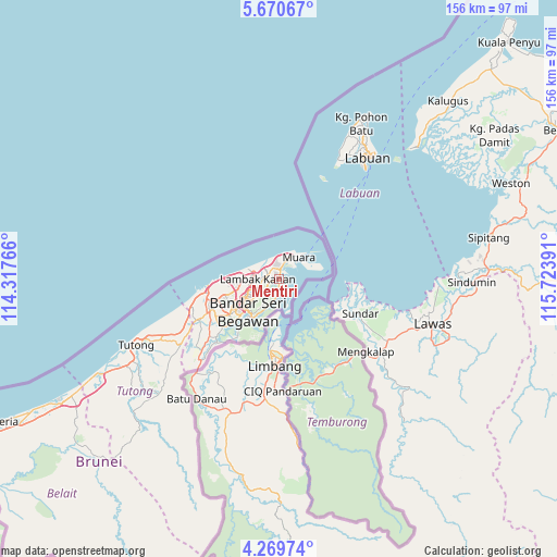
Mentiri GPS coordinates[2]
4° 58' 14.088" North, 115° 1' 14.808" East
| Map corner | latitude | longitude |
|---|---|---|
| Upper-left | 5.67067°, | 114.31766° |
| Center: | 4.97058°, | 115.02078° |
| Lower-right: | 4.26974°, | 115.72391° |
| Map W x H: | 155.8×155.8 km | = 96.8×96.8mi |
| max Lat: | 5.02447° ⇑16.7% North |
| Mentiri: | 4.97058° |
| min Lat: | ⇓83.3% South 4.58361° |
| min Long | Mentiri | max Long |
| 114.2312° | 115.02078° | 115.07167° |
| W 66.7%⇐ | ⇒33.3% E |
Elevation
Elevation of Mentiri is 1 m = 3 ft, and this is 13.1 m = 43 ft below average elevation for this country.
| Max E: |
75 m = 246 ft | 100% |
| Avg. | 14.1 m = 46 ft | |
| Mentiri | 1 m = 3 ft | |
Min E: |
1 m = 3 ft | 0% |
See also: Brunei elevation on elevation.city.
Geographical zone
Mentiri is located in North Torrid zone (between Equator and Tropic of Cancer). Distance of Equator is 552.7 km =343.4 mi to South.| Distance of | km | miles | from Mentiri |
|---|---|---|---|
| North Pole | 9454.4 | 5874.7 | to North |
| Arctic Circle | 6848.5 | 4255.5 | to North |
| Tropic Cancer | 2053.2 | 1275.8 | to North |
| Equator | 552.7 | 343.4 | to South |


Nearby cities:
6 places around Mentiri: (largest is in red/bold)
• Bandar Seri Begawan
12.6 km =7.8 mi,  225°
225°
• Bangar
29.7 km =18.5 mi,  169°
169°
• Kapok
6.6 km =4.1 mi,  25°
25°
• Kuala Belait
97.5 km =60.6 mi,  243°
243°
• Seria
87.1 km =54.1 mi, 242°
• Tutong
45.2 km =28.1 mi,  245°
245°
Sources, notices
• [Note1] Compared only with cities in Brunei existing in our database
• [Src1] Map data: © OpenStreetMap contributors (CC-BY-SA)
• [Src2] Other city data from geonames.org with taken over terms of usage.
• [Src3] Geographical zone / Annual Mean Temperature by Robert A. Rohde @ Wikipedia
