Bangar geodata
Bangar (Temburong) is a seat of a first-order administrative division; located in Brunei in Asia/Brunei (GMT+8) time zone. With population of 3,970 people, there are 5 cities with bigger population in this country. Compared to other cities in Brunei, 66.7% of cities are located further ↑North; 100% of cities are located further ←West and 100% of cities have lower elevation than Bangar. Note1


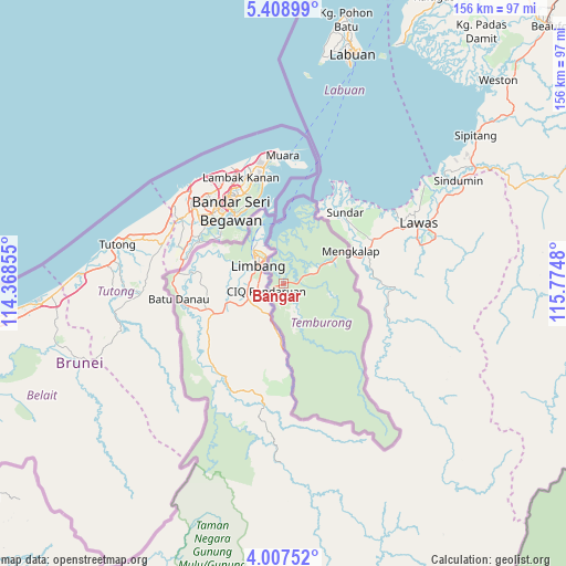
Bangar GPS coordinates[2]
4° 42' 30.996" North, 115° 4' 18.012" East
| Map corner | latitude | longitude |
|---|---|---|
| Upper-left | 5.40899°, | 114.36855° |
| Center: | 4.70861°, | 115.07167° |
| Lower-right: | 4.00752°, | 115.7748° |
| Map W x H: | 155.8×155.8 km | = 96.8×96.8mi |
| max Lat: | 5.02447° ⇑66.7% North |
| Bangar: | 4.70861° |
| min Lat: | ⇓33.3% South 4.58361° |
| min Long | Bangar | max Long |
| 114.2312° | 115.07167° | 115.07167° |
| W 100%⇐ | ⇒0% E |
Elevation
Elevation of Bangar is 75 m = 246 ft, and this is 60.9 m = 200 ft above average elevation for this country.
| Max E: |
75 m = 246 ft | 0% |
| Bangar | 75 m 246 ft | |
| Avg. | 14.1 m = 46 ft | |
Min E: |
1 m = 3 ft | 100% |
See also: Brunei elevation on elevation.city.
Geographical zone
Bangar is located in North Torrid zone (between Equator and Tropic of Cancer). Distance of Equator is 523.5 km =325.3 mi to South.| Distance of | km | miles | from Bangar |
|---|---|---|---|
| North Pole | 9483.5 | 5892.8 | to North |
| Arctic Circle | 6877.6 | 4273.5 | to North |
| Tropic Cancer | 2082.4 | 1293.9 | to North |
| Equator | 523.5 | 325.3 | to South |


Nearby cities:
6 places around Bangar: (largest is in red/bold)
• Bandar Seri Begawan
24.9 km =15.5 mi,  324°
324°
• Kapok
35.2 km =21.9 mi,  355°
355°
• Kuala Belait
94.2 km =58.5 mi,  261°
261°
• Mentiri
29.7 km =18.5 mi,  349°
349°
• Seria
83.6 km =51.9 mi, 262°
• Tutong
48 km =29.8 mi,  282°
282°
Sources, notices
• [Note1] Compared only with cities in Brunei existing in our database
• [Src1] Map data: © OpenStreetMap contributors (CC-BY-SA)
• [Src2] Other city data from geonames.org with taken over terms of usage.
• [Src3] Geographical zone / Annual Mean Temperature by Robert A. Rohde @ Wikipedia
