Sucre geodata
Sucre (Chuquisaca) is a capital of a political entity; located in Bolivia in America/La_Paz (GMT-4) time zone. With population of 224,838 people, there are 3 cities with bigger population in this country. Compared to other cities in Bolivia, 71.4% of cities are located further ↑North; 51.6% of cities are located further →East and 64.6% of cities have lower elevation than Sucre. Note1


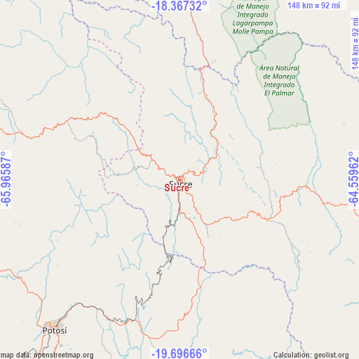
Sucre GPS coordinates[2]
19° 1' 59.952" South, 65° 15' 45.864" West
| Map corner | latitude | longitude |
|---|---|---|
| Upper-left | -18.36732°, | -65.96587° |
| Center: | -19.03332°, | -65.26274° |
| Lower-right: | -19.69666°, | -64.55962° |
| Map W x H: | 147.8×147.8 km | = 91.8×91.8mi |
| max Lat: | -9.71828° ⇑71.4% North |
| Sucre: | -19.03332° |
| min Lat: | ⇓28.6% South -22.73206° |
| min Long | Sucre | max Long |
| -69.14843° | -65.26274° | -57.76667° |
| W 48.4%⇐ | ⇒51.6% E |
Elevation
Elevation of Sucre is 2798 m = 9180 ft, and this is 786.7 m = 2581 ft above average elevation for this country.
| Max E: |
4732 m = 15525 ft | 35.4% |
| Sucre | 2798 m 9180 ft | |
| Avg. | 2011.3 m = 6599 ft | |
Min E: |
92 m = 302 ft | 64.6% |
See also: Sucre elevation on elevation.city.
Geographical zone
Sucre is located in South Torrid zone (between Equator and Tropic of Capricorn). Distance of this Southern Tropic circle is 489.6 km =304.2 mi to South.| Distance of | km | miles | from Sucre |
|---|---|---|---|
| Equator | 2116.3 | 1315 | to North |
| Tropic Capricorn | 489.6 | 304.2 | to South |
| Antarctic Circle | 5284.9 | 3283.9 | to South |
| South Pole | 7890.8 | 4903.1 | to South |


Nearby cities:
15 places around Sucre: (largest is in red/bold)
• Chaunaca
21.5 km =13.4 mi,  274°
274°
• Chuqui Chuqui
31.7 km =19.7 mi,  40°
40°
• Huata
2.3 km =1.4 mi, 35°
• Huayllas
16.6 km =10.3 mi,  203°
203°
• Maragua
17.5 km =10.9 mi, 265°
• Mojotoro
24.4 km =15.2 mi,  57°
57°
• Piocera
34.7 km =21.6 mi,  335°
335°
• Pocpo
24.8 km =15.4 mi,  333°
333°
• Potolo
28.1 km =17.5 mi,  276°
276°
• Presto
35.9 km =22.3 mi,  71°
71°
• Pulqui
22.8 km =14.2 mi,  167°
167°
• Sotomayor
43.9 km =27.3 mi,  140°
140°
• Tarabuco
40.1 km =24.9 mi,  114°
114°
• Yamparáez
22.7 km =14.1 mi, 139°
• Yotala
13.9 km =8.6 mi,  180°
180°
Sources, notices
• [Note1] Compared only with cities in Bolivia existing in our database
• [Src1] Map data: © OpenStreetMap contributors (CC-BY-SA)
• [Src2] Other city data from geonames.org with taken over terms of usage.
• [Src3] Geographical zone / Annual Mean Temperature by Robert A. Rohde @ Wikipedia
