Ubajara geodata
Ubajara (Ceará) is a populated place; located in Brazil in America/Fortaleza (GMT-3) time zone. With population of 13,802 people, there are 1306 cities with bigger population in this country. Compared to other cities in Brazil, 91.9% of cities are located further ↓South; 70.4% of cities are located further ←West and 92.7% of cities have lower elevation than Ubajara. Note1


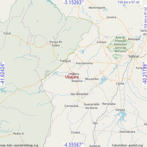
Ubajara GPS coordinates[2]
3° 51' 15.984" South, 40° 55' 15.996" West
| Map corner | latitude | longitude |
|---|---|---|
| Upper-left | -3.15263°, | -41.62424° |
| Center: | -3.85444°, | -40.92111° |
| Lower-right: | -4.55567°, | -40.21799° |
| Map W x H: | 156×156 km | = 96.9×96.9mi |
| max Lat: | 2.81972° ⇑8.1% North |
| Ubajara: | -3.85444° |
| min Lat: | ⇓91.9% South -33.69111° |
| min Long | Ubajara | max Long |
| -72.89583° | -40.92111° | -32.41083° |
| W 70.4%⇐ | ⇒29.6% E |
Elevation
Elevation of Ubajara is 855 m = 2805 ft, and this is 474.1 m = 1555 ft above average elevation for this country.
| Max E: |
1603 m = 5259 ft | 7.3% |
| Ubajara | 855 m 2805 ft | |
| Avg. | 380.9 m = 1250 ft | |
Min E: |
0 m = 0 ft | 92.7% |
See also: Brazil elevation on elevation.city.
Geographical zone
Ubajara is located in South Torrid zone (between Equator and Tropic of Capricorn). Distance of Equator is 428.6 km =266.3 mi to North.| Distance of | km | miles | from Ubajara |
|---|---|---|---|
| Equator | 428.6 | 266.3 | to North |
| Tropic Capricorn | 2177.3 | 1352.9 | to South |
| Antarctic Circle | 6972.6 | 4332.6 | to South |
| South Pole | 9578.5 | 5951.8 | to South |


Nearby cities:
15 places around Ubajara: (largest is in red/bold)
• Cariré
50.8 km =31.6 mi,  102°
102°
• Cocal
82.4 km =51.2 mi,  301°
301°
• Coreaú
46.2 km =28.7 mi,  39°
39°
• Forquilha
73.5 km =45.7 mi,  85°
85°
• Granja
82.3 km =51.1 mi,  7°
7°
• Guaraciaba do Norte
39.7 km =24.7 mi,  151°
151°
• Hidrolândia
81.6 km =50.7 mi,  138°
138°
• Ibiapina
8.4 km =5.2 mi,  155°
155°
• Ipu
57 km =35.4 mi, 155°
• Juá dos Vieiras
55.2 km =34.3 mi,  310°
310°
• Reriutaba
49.3 km =30.6 mi,  130°
130°
• Sobral
66.1 km =41.1 mi,  73°
73°
• Tianguá
15.7 km =9.8 mi,  330°
330°
• Varjota
62.1 km =38.6 mi, 127°
• Viçosa do Ceará
37.6 km =23.4 mi, 329°
Sources, notices
• [Note1] Compared only with cities in Brazil existing in our database
• [Src1] Map data: © OpenStreetMap contributors (CC-BY-SA)
• [Src2] Other city data from geonames.org with taken over terms of usage.
• [Src3] Geographical zone / Annual Mean Temperature by Robert A. Rohde @ Wikipedia
