Ipu geodata
Ipu (Ceará) is a populated place; located in Brazil in America/Fortaleza (GMT-3) time zone. With population of 26,678 people, there are 745 cities with bigger population in this country. Compared to other cities in Brazil, 90.1% of cities are located further ↓South; 71.5% of cities are located further ←West and 56.5% of cities have higher elevation than Ipu. Note1


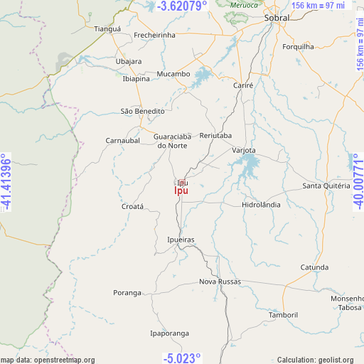
Ipu GPS coordinates[2]
4° 19' 19.992" South, 40° 42' 38.988" West
| Map corner | latitude | longitude |
|---|---|---|
| Upper-left | -3.62079°, | -41.41396° |
| Center: | -4.32222°, | -40.71083° |
| Lower-right: | -5.023°, | -40.00771° |
| Map W x H: | 155.9×155.9 km | = 96.9×96.9mi |
| max Lat: | 2.81972° ⇑9.9% North |
| Ipu: | -4.32222° |
| min Lat: | ⇓90.1% South -33.69111° |
| min Long | Ipu | max Long |
| -72.89583° | -40.71083° | -32.41083° |
| W 71.5%⇐ | ⇒28.5% E |
Elevation
Elevation of Ipu is 250 m = 820 ft, and this is 130.9 m = 429 ft below average elevation for this country.
| Max E: |
1603 m = 5259 ft | 56.5% |
| Avg. | 380.9 m = 1250 ft | |
| Ipu | 250 m = 820 ft | |
Min E: |
0 m = 0 ft | 43.5% |
See also: Brazil elevation on elevation.city.
Geographical zone
Ipu is located in South Torrid zone (between Equator and Tropic of Capricorn). Distance of Equator is 480.6 km =298.6 mi to North.| Distance of | km | miles | from Ipu |
|---|---|---|---|
| Equator | 480.6 | 298.6 | to North |
| Tropic Capricorn | 2125.3 | 1320.6 | to South |
| Antarctic Circle | 6920.6 | 4300.3 | to South |
| South Pole | 9526.5 | 5919.5 | to South |


Nearby cities:
15 places around Ipu: (largest is in red/bold)
• Cariré
49 km =30.4 mi,  32°
32°
• Coreaú
87.9 km =54.6 mi,  3°
3°
• Forquilha
76.7 km =47.7 mi,  40°
40°
• Guaraciaba do Norte
17.7 km =11 mi,  346°
346°
• Hidrolândia
31.7 km =19.7 mi,  107°
107°
• Ibiapina
48.6 km =30.2 mi,  335°
335°
• Nova Russas
45.8 km =28.5 mi,  159°
159°
• Pedro II
83.7 km =52 mi,  262°
262°
• Reriutaba
24.6 km =15.3 mi, 35°
• Santa Quitéria
61.5 km =38.2 mi,  91°
91°
• Sobral
81.3 km =50.5 mi, 29°
• Tamboril
71.3 km =44.3 mi,  142°
142°
• Tianguá
72.6 km =45.1 mi,  334°
334°
• Ubajara
57 km =35.4 mi, 335°
• Varjota
29.6 km =18.4 mi,  61°
61°
Sources, notices
• [Note1] Compared only with cities in Brazil existing in our database
• [Src1] Map data: © OpenStreetMap contributors (CC-BY-SA)
• [Src2] Other city data from geonames.org with taken over terms of usage.
• [Src3] Geographical zone / Annual Mean Temperature by Robert A. Rohde @ Wikipedia
