Forquilha geodata
Forquilha (Ceará) is a populated place; located in Brazil in America/Fortaleza (GMT-3) time zone. With population of 13,409 people, there are 1340 cities with bigger population in this country. Compared to other cities in Brazil, 92.1% of cities are located further ↓South; 74.3% of cities are located further ←West and 73.4% of cities have higher elevation than Forquilha. Note1


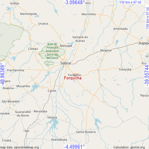
Forquilha GPS coordinates[2]
3° 47' 53.988" South, 40° 15' 38.016" West
| Map corner | latitude | longitude |
|---|---|---|
| Upper-left | -3.09648°, | -40.96369° |
| Center: | -3.79833°, | -40.26056° |
| Lower-right: | -4.49961°, | -39.55744° |
| Map W x H: | 156×156 km | = 96.9×96.9mi |
| max Lat: | 2.81972° ⇑7.9% North |
| Forquilha: | -3.79833° |
| min Lat: | ⇓92.1% South -33.69111° |
| min Long | Forquilha | max Long |
| -72.89583° | -40.26056° | -32.41083° |
| W 74.3%⇐ | ⇒25.7% E |
Elevation
Elevation of Forquilha is 92 m = 302 ft, and this is 288.9 m = 948 ft below average elevation for this country.
| Max E: |
1603 m = 5259 ft | 73.4% |
| Avg. | 380.9 m = 1250 ft | |
| Forquilha | 92 m = 302 ft | |
Min E: |
0 m = 0 ft | 26.6% |
See also: Brazil elevation on elevation.city.
Geographical zone
Forquilha is located in South Torrid zone (between Equator and Tropic of Capricorn). Distance of Equator is 422.3 km =262.4 mi to North.| Distance of | km | miles | from Forquilha |
|---|---|---|---|
| Equator | 422.3 | 262.4 | to North |
| Tropic Capricorn | 2183.6 | 1356.8 | to South |
| Antarctic Circle | 6978.8 | 4336.4 | to South |
| South Pole | 9584.7 | 5955.7 | to South |


Nearby cities:
15 places around Forquilha: (largest is in red/bold)
• Amontada
68 km =42.3 mi,  44°
44°
• Cariré
29 km =18 mi,  234°
234°
• Coreaú
52.9 km =32.9 mi,  303°
303°
• Guaraciaba do Norte
67.8 km =42.1 mi, 232°
• Hidrolândia
70.6 km =43.9 mi,  196°
196°
• Ibiapina
71.1 km =44.2 mi,  258°
258°
• Irauçuba
53.3 km =33.1 mi,  83°
83°
• Itapagé
75.9 km =47.2 mi, 80°
• Marco
76 km =47.2 mi,  9°
9°
• Reriutaba
52.3 km =32.5 mi,  223°
223°
• Santa Quitéria
60.4 km =37.5 mi,  169°
169°
• Santana do Acaraú
37.9 km =23.5 mi, 8°
• Sobral
15.9 km =9.9 mi,  321°
321°
• Ubajara
73.5 km =45.7 mi,  265°
265°
• Varjota
50.1 km =31.1 mi,  208°
208°
Sources, notices
• [Note1] Compared only with cities in Brazil existing in our database
• [Src1] Map data: © OpenStreetMap contributors (CC-BY-SA)
• [Src2] Other city data from geonames.org with taken over terms of usage.
• [Src3] Geographical zone / Annual Mean Temperature by Robert A. Rohde @ Wikipedia
