Tutóia geodata
Tutóia (Maranhão) is a populated place; located in Brazil in America/Fortaleza (GMT-3) time zone. With population of 12,212 people, there are 1459 cities with bigger population in this country. Compared to other cities in Brazil, 96.1% of cities are located further ↓South; 64.6% of cities are located further ←West and 99% of cities have higher elevation than Tutóia. Note1


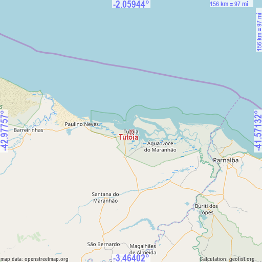
Tutóia GPS coordinates[2]
2° 45' 42.984" South, 42° 16' 27.984" West
| Map corner | latitude | longitude |
|---|---|---|
| Upper-left | -2.05944°, | -42.97757° |
| Center: | -2.76194°, | -42.27444° |
| Lower-right: | -3.46402°, | -41.57132° |
| Map W x H: | 156.2×156.2 km | = 97.1×97.1mi |
| max Lat: | 2.81972° ⇑3.9% North |
| Tutóia: | -2.76194° |
| min Lat: | ⇓96.1% South -33.69111° |
| min Long | Tutóia | max Long |
| -72.89583° | -42.27444° | -32.41083° |
| W 64.6%⇐ | ⇒35.4% E |
Elevation
Elevation of Tutóia is 5 m = 16 ft, and this is 375.9 m = 1233 ft below average elevation for this country.
| Max E: |
1603 m = 5259 ft | 99% |
| Avg. | 380.9 m = 1250 ft | |
| Tutóia | 5 m = 16 ft | |
Min E: |
0 m = 0 ft | 1% |
See also: Brazil elevation on elevation.city.
Geographical zone
Tutóia is located in South Torrid zone (between Equator and Tropic of Capricorn). Distance of Equator is 307.1 km =190.8 mi to North.| Distance of | km | miles | from Tutóia |
|---|---|---|---|
| Equator | 307.1 | 190.8 | to North |
| Tropic Capricorn | 2298.8 | 1428.4 | to South |
| Antarctic Circle | 7094.1 | 4408.1 | to South |
| South Pole | 9700 | 6027.3 | to South |


Nearby cities:
15 places around Tutóia: (largest is in red/bold)
• Araioses
43.6 km =27.1 mi,  109°
109°
• Atins
56.2 km =34.9 mi,  292°
292°
• Barreirinhas
61.3 km =38.1 mi,  270°
270°
• Barroquinha
129.6 km =80.5 mi,  102°
102°
• Brejo
115.4 km =71.7 mi,  207°
207°
• Buriti dos Lopes
64.5 km =40.1 mi,  135°
135°
• Cocal
112.1 km =69.7 mi,  134°
134°
• Esperantina
126.8 km =78.8 mi,  177°
177°
• Humberto de Campos
133.1 km =82.7 mi,  277°
277°
• Luzilândia
78.1 km =48.5 mi,  187°
187°
• Luís Correia
68.7 km =42.7 mi, 100°
• Matias Olímpio
110.6 km =68.7 mi,  196°
196°
• Parnaíba
57.5 km =35.7 mi, 106°
• Santa Quitéria do Maranhão
89.1 km =55.4 mi, 199°
• São Bernardo
68.5 km =42.6 mi, 193°
Sources, notices
• [Note1] Compared only with cities in Brazil existing in our database
• [Src1] Map data: © OpenStreetMap contributors (CC-BY-SA)
• [Src2] Other city data from geonames.org with taken over terms of usage.
• [Src3] Geographical zone / Annual Mean Temperature by Robert A. Rohde @ Wikipedia
