São Bernardo geodata
São Bernardo (Maranhão) is a populated place; located in Brazil in America/Fortaleza (GMT-3) time zone. With population of 11,171 people, there are 1552 cities with bigger population in this country. Compared to other cities in Brazil, 94.2% of cities are located further ↓South; 63.9% of cities are located further ←West and 85.7% of cities have higher elevation than São Bernardo. Note1


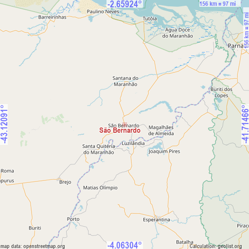
São Bernardo GPS coordinates[2]
3° 21' 41.004" South, 42° 25' 4.008" West
| Map corner | latitude | longitude |
|---|---|---|
| Upper-left | -2.65924°, | -43.12091° |
| Center: | -3.36139°, | -42.41778° |
| Lower-right: | -4.06304°, | -41.71466° |
| Map W x H: | 156.1×156.1 km | = 97×97mi |
| max Lat: | 2.81972° ⇑5.8% North |
| São Bernardo: | -3.36139° |
| min Lat: | ⇓94.2% South -33.69111° |
| min Long | São Bernardo | max Long |
| -72.89583° | -42.41778° | -32.41083° |
| W 63.9%⇐ | ⇒36.1% E |
Elevation
Elevation of São Bernardo is 29 m = 95 ft, and this is 351.9 m = 1155 ft below average elevation for this country.
| Max E: |
1603 m = 5259 ft | 85.7% |
| Avg. | 380.9 m = 1250 ft | |
| São Bernardo | 29 m = 95 ft | |
Min E: |
0 m = 0 ft | 14.3% |
See also: Brazil elevation on elevation.city.
Geographical zone
São Bernardo is located in South Torrid zone (between Equator and Tropic of Capricorn). Distance of Equator is 373.8 km =232.3 mi to North.| Distance of | km | miles | from São Bernardo |
|---|---|---|---|
| Equator | 373.8 | 232.3 | to North |
| Tropic Capricorn | 2232.2 | 1387 | to South |
| Antarctic Circle | 7027.4 | 4366.6 | to South |
| South Pole | 9633.3 | 5985.9 | to South |


Nearby cities:
15 places around São Bernardo: (largest is in red/bold)
• Araioses
77.5 km =48.2 mi,  47°
47°
• Atins
95.1 km =59.1 mi,  337°
337°
• Barreirinhas
81.2 km =50.5 mi,  326°
326°
• Batalha
83 km =51.6 mi,  152°
152°
• Brejo
51.5 km =32 mi,  225°
225°
• Buriti dos Lopes
64.6 km =40.1 mi,  71°
71°
• Cocal
96.3 km =59.8 mi,  97°
97°
• Esperantina
63.5 km =39.5 mi,  161°
161°
• Luzilândia
11.9 km =7.4 mi, 153°
• Luís Correia
99.1 km =61.6 mi,  57°
57°
• Matias Olímpio
42.3 km =26.3 mi,  201°
201°
• Parnaíba
87.4 km =54.3 mi, 54°
• Porto
67.5 km =41.9 mi,  208°
208°
• Santa Quitéria do Maranhão
22.3 km =13.9 mi,  219°
219°
• Tutóia
68.5 km =42.6 mi,  13°
13°
Sources, notices
• [Note1] Compared only with cities in Brazil existing in our database
• [Src1] Map data: © OpenStreetMap contributors (CC-BY-SA)
• [Src2] Other city data from geonames.org with taken over terms of usage.
• [Src3] Geographical zone / Annual Mean Temperature by Robert A. Rohde @ Wikipedia
