Luís Correia geodata
Luís Correia (Piauí) is a populated place; located in Brazil in America/Fortaleza (GMT-3) time zone. With population of 11,479 people, there are 1526 cities with bigger population in this country. Compared to other cities in Brazil, 95.8% of cities are located further ↓South; 67.5% of cities are located further ←West and 99.5% of cities have higher elevation than Luís Correia. Note1


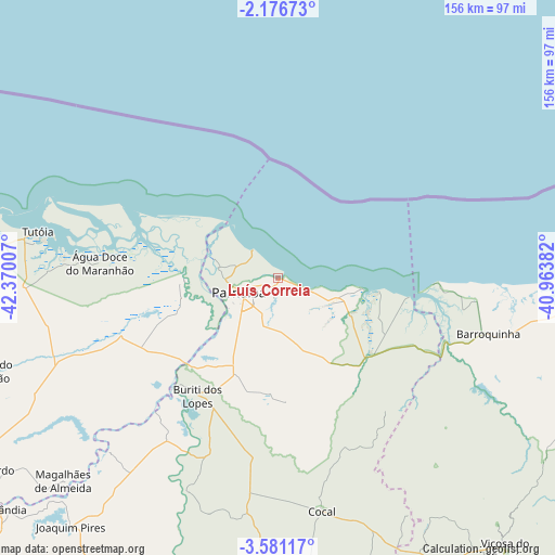
Luís Correia GPS coordinates[2]
2° 52' 45.012" South, 41° 40' 0.984" West
| Map corner | latitude | longitude |
|---|---|---|
| Upper-left | -2.17673°, | -42.37007° |
| Center: | -2.87917°, | -41.66694° |
| Lower-right: | -3.58117°, | -40.96382° |
| Map W x H: | 156.2×156.2 km | = 97.1×97.1mi |
| max Lat: | 2.81972° ⇑4.2% North |
| Luís Correia: | -2.87917° |
| min Lat: | ⇓95.8% South -33.69111° |
| min Long | Luís Correia | max Long |
| -72.89583° | -41.66694° | -32.41083° |
| W 67.5%⇐ | ⇒32.5% E |
Elevation
Elevation of Luís Correia is 3 m = 10 ft, and this is 377.9 m = 1240 ft below average elevation for this country.
| Max E: |
1603 m = 5259 ft | 99.5% |
| Avg. | 380.9 m = 1250 ft | |
| Luís Correia | 3 m = 10 ft | |
Min E: |
0 m = 0 ft | 0.5% |
See also: Brazil elevation on elevation.city.
Geographical zone
Luís Correia is located in South Torrid zone (between Equator and Tropic of Capricorn). Distance of Equator is 320.1 km =198.9 mi to North.| Distance of | km | miles | from Luís Correia |
|---|---|---|---|
| Equator | 320.1 | 198.9 | to North |
| Tropic Capricorn | 2285.8 | 1420.3 | to South |
| Antarctic Circle | 7081 | 4399.9 | to South |
| South Pole | 9686.9 | 6019.2 | to South |


Nearby cities:
15 places around Luís Correia: (largest is in red/bold)
• Araioses
26.2 km =16.3 mi,  267°
267°
• Barroquinha
61 km =37.9 mi,  104°
104°
• Buriti dos Lopes
39.7 km =24.7 mi,  214°
214°
• Camocim
91.7 km =57 mi,  91°
91°
• Cocal
67 km =41.6 mi,  169°
169°
• Granja
97.1 km =60.3 mi,  106°
106°
• Juá dos Vieiras
83.4 km =51.8 mi,  150°
150°
• Luzilândia
101.2 km =62.9 mi,  230°
230°
• Parnaíba
12.5 km =7.8 mi,  256°
256°
• Piracuruca
116.7 km =72.5 mi,  182°
182°
• Santa Quitéria do Maranhão
120.6 km =74.9 mi, 234°
• São Bernardo
99.1 km =61.6 mi,  237°
237°
• Tianguá
120.9 km =75.1 mi,  141°
141°
• Tutóia
68.7 km =42.7 mi,  280°
280°
• Viçosa do Ceará
99.2 km =61.6 mi, 139°
Sources, notices
• [Note1] Compared only with cities in Brazil existing in our database
• [Src1] Map data: © OpenStreetMap contributors (CC-BY-SA)
• [Src2] Other city data from geonames.org with taken over terms of usage.
• [Src3] Geographical zone / Annual Mean Temperature by Robert A. Rohde @ Wikipedia
