Trindade geodata
Trindade (Pernambuco) is a populated place; located in Brazil in America/Recife (GMT-3) time zone. With population of 19,313 people, there are 968 cities with bigger population in this country. Compared to other cities in Brazil, 76.2% of cities are located further ↓South; 74.2% of cities are located further ←West and 64.7% of cities have lower elevation than Trindade. Note1


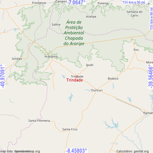
Trindade GPS coordinates[2]
7° 45' 42.984" South, 40° 16' 4.008" West
| Map corner | latitude | longitude |
|---|---|---|
| Upper-left | -7.0647°, | -40.97091° |
| Center: | -7.76194°, | -40.26778° |
| Lower-right: | -8.45803°, | -39.56466° |
| Map W x H: | 154.9×154.9 km | = 96.3×96.3mi |
| max Lat: | 2.81972° ⇑23.8% North |
| Trindade: | -7.76194° |
| min Lat: | ⇓76.2% South -33.69111° |
| min Long | Trindade | max Long |
| -72.89583° | -40.26778° | -32.41083° |
| W 74.2%⇐ | ⇒25.8% E |
Elevation
Elevation of Trindade is 523 m = 1716 ft, and this is 142.1 m = 466 ft above average elevation for this country.
| Max E: |
1603 m = 5259 ft | 35.3% |
| Trindade | 523 m 1716 ft | |
| Avg. | 380.9 m = 1250 ft | |
Min E: |
0 m = 0 ft | 64.7% |
See also: Brazil elevation on elevation.city.
Geographical zone
Trindade is located in South Torrid zone (between Equator and Tropic of Capricorn). Distance of Equator is 863 km =536.2 mi to North.| Distance of | km | miles | from Trindade |
|---|---|---|---|
| Equator | 863 | 536.2 | to North |
| Tropic Capricorn | 1742.9 | 1083 | to South |
| Antarctic Circle | 6538.1 | 4062.6 | to South |
| South Pole | 9144 | 5681.8 | to South |


Nearby cities:
15 places around Trindade: (largest is in red/bold)
• Araripe
65.8 km =40.9 mi,  21°
21°
• Araripina
32.7 km =20.3 mi,  309°
309°
• Assaré
107.8 km =67 mi, 23°
• Barbalha
117.5 km =73 mi,  64°
64°
• Campos Sales
77.4 km =48.1 mi,  351°
351°
• Crato
111.3 km =69.2 mi, 58°
• Exu
66 km =41 mi,  65°
65°
• Farias Brito
120.6 km =74.9 mi,  39°
39°
• Ipubi
17.9 km =11.1 mi,  46°
46°
• Ipueiras
83.5 km =51.9 mi, 346°
• Jaicós
105.8 km =65.7 mi,  295°
295°
• Ouricuri
24.5 km =15.2 mi,  123°
123°
• Parnamirim
84.3 km =52.4 mi, 115°
• Pio IX
108.4 km =67.4 mi,  341°
341°
• Simões
63.3 km =39.3 mi,  286°
286°
Sources, notices
• [Note1] Compared only with cities in Brazil existing in our database
• [Src1] Map data: © OpenStreetMap contributors (CC-BY-SA)
• [Src2] Other city data from geonames.org with taken over terms of usage.
• [Src3] Geographical zone / Annual Mean Temperature by Robert A. Rohde @ Wikipedia
