Assaré geodata
Assaré (Ceará) is a populated place; located in Brazil in America/Fortaleza (GMT-3) time zone. With population of 11,369 people, there are 1533 cities with bigger population in this country. Compared to other cities in Brazil, 81.1% of cities are located further ↓South; 75.7% of cities are located further ←West and 57.5% of cities have lower elevation than Assaré. Note1


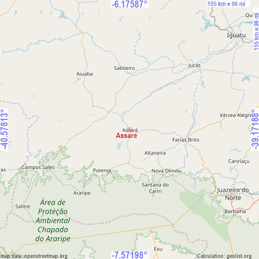
Assaré GPS coordinates[2]
6° 52' 27.984" South, 39° 52' 30" West
| Map corner | latitude | longitude |
|---|---|---|
| Upper-left | -6.17587°, | -40.57813° |
| Center: | -6.87444°, | -39.875° |
| Lower-right: | -7.57198°, | -39.17188° |
| Map W x H: | 155.2×155.2 km | = 96.4×96.4mi |
| max Lat: | 2.81972° ⇑18.9% North |
| Assaré: | -6.87444° |
| min Lat: | ⇓81.1% South -33.69111° |
| min Long | Assaré | max Long |
| -72.89583° | -39.875° | -32.41083° |
| W 75.7%⇐ | ⇒24.3% E |
Elevation
Elevation of Assaré is 446 m = 1463 ft, and this is 65.1 m = 214 ft above average elevation for this country.
| Max E: |
1603 m = 5259 ft | 42.5% |
| Assaré | 446 m 1463 ft | |
| Avg. | 380.9 m = 1250 ft | |
Min E: |
0 m = 0 ft | 57.5% |
See also: Brazil elevation on elevation.city.
Geographical zone
Assaré is located in South Torrid zone (between Equator and Tropic of Capricorn). Distance of Equator is 764.4 km =475 mi to North.| Distance of | km | miles | from Assaré |
|---|---|---|---|
| Equator | 764.4 | 475 | to North |
| Tropic Capricorn | 1841.6 | 1144.3 | to South |
| Antarctic Circle | 6636.8 | 4123.9 | to South |
| South Pole | 9242.7 | 5743.1 | to South |


Nearby cities:
15 places around Assaré: (largest is in red/bold)
• Araripe
42.1 km =26.2 mi,  206°
206°
• Barbalha
79.5 km =49.4 mi,  127°
127°
• Campos Sales
59.6 km =37 mi,  248°
248°
• Caririaçu
67.9 km =42.2 mi,  105°
105°
• Cedro
94.6 km =58.8 mi,  71°
71°
• Crato
65.1 km =40.5 mi, 127°
• Exu
72.8 km =45.2 mi,  166°
166°
• Farias Brito
34.7 km =21.6 mi,  100°
100°
• Iguatu
85.6 km =53.2 mi,  48°
48°
• Ipubi
91.6 km =56.9 mi,  199°
199°
• Ipueiras
65.9 km =40.9 mi, 254°
• Juazeiro do Norte
72.3 km =44.9 mi,  121°
121°
• Jucás
54.6 km =33.9 mi,  44°
44°
• Missão Velha
90.9 km =56.5 mi, 117°
• Pio IX
77.8 km =48.3 mi,  273°
273°
Sources, notices
• [Note1] Compared only with cities in Brazil existing in our database
• [Src1] Map data: © OpenStreetMap contributors (CC-BY-SA)
• [Src2] Other city data from geonames.org with taken over terms of usage.
• [Src3] Geographical zone / Annual Mean Temperature by Robert A. Rohde @ Wikipedia
