Exu geodata
Exu (Pernambuco) is a populated place; located in Brazil in America/Recife (GMT-3) time zone. With population of 10,875 people, there are 1577 cities with bigger population in this country. Compared to other cities in Brazil, 77.6% of cities are located further ↓South; 76.4% of cities are located further ←West and 64.9% of cities have lower elevation than Exu. Note1


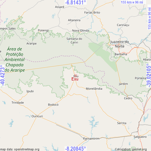
Exu GPS coordinates[2]
7° 30' 42.984" South, 39° 43' 27.012" West
| Map corner | latitude | longitude |
|---|---|---|
| Upper-left | -6.81431°, | -40.4273° |
| Center: | -7.51194°, | -39.72417° |
| Lower-right: | -8.20845°, | -39.02105° |
| Map W x H: | 155×155 km | = 96.3×96.3mi |
| max Lat: | 2.81972° ⇑22.4% North |
| Exu: | -7.51194° |
| min Lat: | ⇓77.6% South -33.69111° |
| min Long | Exu | max Long |
| -72.89583° | -39.72417° | -32.41083° |
| W 76.4%⇐ | ⇒23.6% E |
Elevation
Elevation of Exu is 525 m = 1722 ft, and this is 144.1 m = 473 ft above average elevation for this country.
| Max E: |
1603 m = 5259 ft | 35.1% |
| Exu | 525 m 1722 ft | |
| Avg. | 380.9 m = 1250 ft | |
Min E: |
0 m = 0 ft | 64.9% |
See also: Brazil elevation on elevation.city.
Geographical zone
Exu is located in South Torrid zone (between Equator and Tropic of Capricorn). Distance of Equator is 835.2 km =519 mi to North.| Distance of | km | miles | from Exu |
|---|---|---|---|
| Equator | 835.2 | 519 | to North |
| Tropic Capricorn | 1770.7 | 1100.3 | to South |
| Antarctic Circle | 6565.9 | 4079.9 | to South |
| South Pole | 9171.8 | 5699.1 | to South |


Nearby cities:
15 places around Exu: (largest is in red/bold)
• Araripe
48.7 km =30.3 mi,  313°
313°
• Araripina
85.6 km =53.2 mi,  265°
265°
• Assaré
72.8 km =45.2 mi,  346°
346°
• Barbalha
51.4 km =31.9 mi,  64°
64°
• Brejo Santo
81.3 km =50.5 mi,  88°
88°
• Campos Sales
86.8 km =53.9 mi,  304°
304°
• Caririaçu
71.3 km =44.3 mi,  42°
42°
• Crato
46.5 km =28.9 mi,  48°
48°
• Farias Brito
67 km =41.6 mi,  15°
15°
• Ipubi
49.3 km =30.6 mi,  251°
251°
• Juazeiro do Norte
56 km =34.8 mi, 53°
• Missão Velha
70.4 km =43.7 mi,  65°
65°
• Ouricuri
57 km =35.4 mi,  223°
223°
• Parnamirim
66.3 km =41.2 mi,  165°
165°
• Trindade
66 km =41 mi, 245°
Sources, notices
• [Note1] Compared only with cities in Brazil existing in our database
• [Src1] Map data: © OpenStreetMap contributors (CC-BY-SA)
• [Src2] Other city data from geonames.org with taken over terms of usage.
• [Src3] Geographical zone / Annual Mean Temperature by Robert A. Rohde @ Wikipedia
