Pio IX geodata
Pio IX (Piauí) is a populated place; located in Brazil in America/Fortaleza (GMT-3) time zone. With population of 4,973 people, there are 1917 cities with bigger population in this country. Compared to other cities in Brazil, 81.3% of cities are located further ↓South; 72.2% of cities are located further ←West and 62.2% of cities have lower elevation than Pio IX. Note1


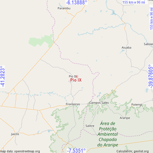
Pio IX GPS coordinates[2]
6° 50' 15" South, 40° 34' 45.012" West
| Map corner | latitude | longitude |
|---|---|---|
| Upper-left | -6.13888°, | -41.2823° |
| Center: | -6.8375°, | -40.57917° |
| Lower-right: | -7.5351°, | -39.87605° |
| Map W x H: | 155.2×155.2 km | = 96.4×96.4mi |
| max Lat: | 2.81972° ⇑18.7% North |
| Pio IX: | -6.8375° |
| min Lat: | ⇓81.3% South -33.69111° |
| min Long | Pio IX | max Long |
| -72.89583° | -40.57917° | -32.41083° |
| W 72.2%⇐ | ⇒27.8% E |
Elevation
Elevation of Pio IX is 498 m = 1634 ft, and this is 117.1 m = 384 ft above average elevation for this country.
| Max E: |
1603 m = 5259 ft | 37.8% |
| Pio IX | 498 m 1634 ft | |
| Avg. | 380.9 m = 1250 ft | |
Min E: |
0 m = 0 ft | 62.2% |
See also: Brazil elevation on elevation.city.
Geographical zone
Pio IX is located in South Torrid zone (between Equator and Tropic of Capricorn). Distance of Equator is 760.3 km =472.4 mi to North.| Distance of | km | miles | from Pio IX |
|---|---|---|---|
| Equator | 760.3 | 472.4 | to North |
| Tropic Capricorn | 1845.7 | 1146.9 | to South |
| Antarctic Circle | 6640.9 | 4126.5 | to South |
| South Pole | 9246.8 | 5745.7 | to South |


Nearby cities:
15 places around Pio IX: (largest is in red/bold)
• Araripe
72.1 km =44.8 mi,  125°
125°
• Araripina
82.6 km =51.3 mi,  173°
173°
• Assaré
77.8 km =48.3 mi,  93°
93°
• Campos Sales
34.6 km =21.5 mi,  139°
139°
• Farias Brito
112.4 km =69.8 mi,  95°
95°
• Ipubi
102.2 km =63.5 mi,  152°
152°
• Ipueiras
26 km =16.2 mi, 146°
• Itainópolis
120.1 km =74.6 mi,  235°
235°
• Jaicós
84.6 km =52.6 mi,  226°
226°
• Parambu
70.8 km =44 mi,  349°
349°
• Picos
101.5 km =63.1 mi,  254°
254°
• Pimenteiras
113.8 km =70.7 mi,  305°
305°
• Simões
88.7 km =55.1 mi,  197°
197°
• São João dos Inhamuns
98.7 km =61.3 mi,  19°
19°
• Trindade
108.4 km =67.4 mi,  161°
161°
Sources, notices
• [Note1] Compared only with cities in Brazil existing in our database
• [Src1] Map data: © OpenStreetMap contributors (CC-BY-SA)
• [Src2] Other city data from geonames.org with taken over terms of usage.
• [Src3] Geographical zone / Annual Mean Temperature by Robert A. Rohde @ Wikipedia
