Taperoá geodata
Taperoá (Paraíba) is a populated place; located in Brazil in America/Fortaleza (GMT-3) time zone. With population of 8,879 people, there are 1724 cities with bigger population in this country. Compared to other cities in Brazil, 79.4% of cities are located further ↓South; 89.7% of cities are located further ←West and 66.1% of cities have lower elevation than Taperoá. Note1


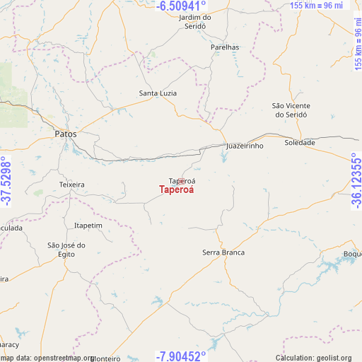
Taperoá GPS coordinates[2]
7° 12' 27" South, 36° 49' 36.012" West
| Map corner | latitude | longitude |
|---|---|---|
| Upper-left | -6.50941°, | -37.5298° |
| Center: | -7.2075°, | -36.82667° |
| Lower-right: | -7.90452°, | -36.12355° |
| Map W x H: | 155.1×155.1 km | = 96.4×96.4mi |
| max Lat: | 2.81972° ⇑20.6% North |
| Taperoá: | -7.2075° |
| min Lat: | ⇓79.4% South -33.69111° |
| min Long | Taperoá | max Long |
| -72.89583° | -36.82667° | -32.41083° |
| W 89.7%⇐ | ⇒10.3% E |
Elevation
Elevation of Taperoá is 533 m = 1749 ft, and this is 152.1 m = 499 ft above average elevation for this country.
| Max E: |
1603 m = 5259 ft | 33.9% |
| Taperoá | 533 m 1749 ft | |
| Avg. | 380.9 m = 1250 ft | |
Min E: |
0 m = 0 ft | 66.1% |
See also: Brazil elevation on elevation.city.
Geographical zone
Taperoá is located in South Torrid zone (between Equator and Tropic of Capricorn). Distance of Equator is 801.4 km =498 mi to North.| Distance of | km | miles | from Taperoá |
|---|---|---|---|
| Equator | 801.4 | 498 | to North |
| Tropic Capricorn | 1804.5 | 1121.3 | to South |
| Antarctic Circle | 6599.8 | 4100.9 | to South |
| South Pole | 9205.7 | 5720.2 | to South |


Nearby cities:
15 places around Taperoá: (largest is in red/bold)
• Boqueirão
82.3 km =51.1 mi,  111°
111°
• Caicó
88.5 km =55 mi,  340°
340°
• Desterro
30.9 km =19.2 mi,  252°
252°
• Imaculada
78 km =48.5 mi, 254°
• Jardim do Seridó
69.5 km =43.2 mi,  4°
4°
• Monteiro
82.4 km =51.2 mi,  203°
203°
• Parelhas
60.7 km =37.7 mi,  17°
17°
• Patos
54 km =33.6 mi,  292°
292°
• Pocinhos
85.7 km =53.3 mi,  80°
80°
• Santa Luzia
38.6 km =24 mi, 344°
• Soledade
53.8 km =33.4 mi,  71°
71°
• Sumé
51.9 km =32.2 mi,  186°
186°
• São José do Egito
57.9 km =36 mi,  238°
238°
• Tabira
89.4 km =55.6 mi, 241°
• Teixeira
47.2 km =29.3 mi,  267°
267°
Sources, notices
• [Note1] Compared only with cities in Brazil existing in our database
• [Src1] Map data: © OpenStreetMap contributors (CC-BY-SA)
• [Src2] Other city data from geonames.org with taken over terms of usage.
• [Src3] Geographical zone / Annual Mean Temperature by Robert A. Rohde @ Wikipedia
