Parelhas geodata
Parelhas (Rio Grande do Norte) is a populated place; located in Brazil in America/Fortaleza (GMT-3) time zone. With population of 16,377 people, there are 1132 cities with bigger population in this country. Compared to other cities in Brazil, 82.1% of cities are located further ↓South; 90.1% of cities are located further ←West and 54.6% of cities have higher elevation than Parelhas. Note1


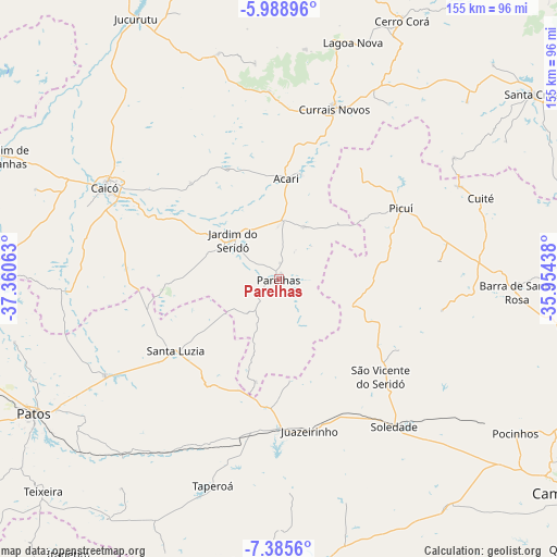
Parelhas GPS coordinates[2]
6° 41' 16.008" South, 36° 39' 27" West
| Map corner | latitude | longitude |
|---|---|---|
| Upper-left | -5.98896°, | -37.36063° |
| Center: | -6.68778°, | -36.6575° |
| Lower-right: | -7.3856°, | -35.95438° |
| Map W x H: | 155.3×155.3 km | = 96.5×96.5mi |
| max Lat: | 2.81972° ⇑17.9% North |
| Parelhas: | -6.68778° |
| min Lat: | ⇓82.1% South -33.69111° |
| min Long | Parelhas | max Long |
| -72.89583° | -36.6575° | -32.41083° |
| W 90.1%⇐ | ⇒9.9% E |
Elevation
Elevation of Parelhas is 274 m = 899 ft, and this is 106.9 m = 351 ft below average elevation for this country.
| Max E: |
1603 m = 5259 ft | 54.6% |
| Avg. | 380.9 m = 1250 ft | |
| Parelhas | 274 m = 899 ft | |
Min E: |
0 m = 0 ft | 45.4% |
See also: Brazil elevation on elevation.city.
Geographical zone
Parelhas is located in South Torrid zone (between Equator and Tropic of Capricorn). Distance of Equator is 743.6 km =462.1 mi to North.| Distance of | km | miles | from Parelhas |
|---|---|---|---|
| Equator | 743.6 | 462.1 | to North |
| Tropic Capricorn | 1862.3 | 1157.2 | to South |
| Antarctic Circle | 6657.6 | 4136.8 | to South |
| South Pole | 9263.5 | 5756.1 | to South |


Nearby cities:
15 places around Parelhas: (largest is in red/bold)
• Caicó
54.9 km =34.1 mi,  297°
297°
• Cerro Corá
79.3 km =49.3 mi,  25°
25°
• Cuité
60.1 km =37.3 mi,  67°
67°
• Currais Novos
49.9 km =31 mi,  18°
18°
• Desterro
82.5 km =51.3 mi,  215°
215°
• Jardim do Seridó
17.3 km =10.7 mi,  311°
311°
• Lagoa Nova
68.1 km =42.3 mi, 16°
• Nova Floresta
56.4 km =35 mi,  62°
62°
• Patos
78.3 km =48.7 mi,  241°
241°
• Picuí
39.6 km =24.6 mi, 60°
• Pocinhos
78.8 km =49 mi,  123°
123°
• Santa Luzia
35.4 km =22 mi,  234°
234°
• Santana do Matos
81.2 km =50.5 mi,  0°
0°
• Soledade
52.4 km =32.6 mi,  141°
141°
• Taperoá
60.7 km =37.7 mi,  197°
197°
Sources, notices
• [Note1] Compared only with cities in Brazil existing in our database
• [Src1] Map data: © OpenStreetMap contributors (CC-BY-SA)
• [Src2] Other city data from geonames.org with taken over terms of usage.
• [Src3] Geographical zone / Annual Mean Temperature by Robert A. Rohde @ Wikipedia
