Imaculada geodata
Imaculada (Paraíba) is a populated place; located in Brazil in America/Fortaleza (GMT-3) time zone. With population of 4,014 people, there are 1964 cities with bigger population in this country. Compared to other cities in Brazil, 78.1% of cities are located further ↓South; 86.8% of cities are located further ←West and 85.5% of cities have lower elevation than Imaculada. Note1


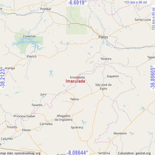
Imaculada GPS coordinates[2]
7° 23' 22.992" South, 37° 30' 33.012" West
| Map corner | latitude | longitude |
|---|---|---|
| Upper-left | -6.6919°, | -38.2123° |
| Center: | -7.38972°, | -37.50917° |
| Lower-right: | -8.08644°, | -36.80605° |
| Map W x H: | 155.1×155.1 km | = 96.4×96.4mi |
| max Lat: | 2.81972° ⇑21.9% North |
| Imaculada: | -7.38972° |
| min Lat: | ⇓78.1% South -33.69111° |
| min Long | Imaculada | max Long |
| -72.89583° | -37.50917° | -32.41083° |
| W 86.8%⇐ | ⇒13.2% E |
Elevation
Elevation of Imaculada is 763 m = 2503 ft, and this is 382.1 m = 1254 ft above average elevation for this country.
| Max E: |
1603 m = 5259 ft | 14.5% |
| Imaculada | 763 m 2503 ft | |
| Avg. | 380.9 m = 1250 ft | |
Min E: |
0 m = 0 ft | 85.5% |
See also: Brazil elevation on elevation.city.
Geographical zone
Imaculada is located in South Torrid zone (between Equator and Tropic of Capricorn). Distance of Equator is 821.7 km =510.6 mi to North.| Distance of | km | miles | from Imaculada |
|---|---|---|---|
| Equator | 821.7 | 510.6 | to North |
| Tropic Capricorn | 1784.3 | 1108.7 | to South |
| Antarctic Circle | 6579.5 | 4088.3 | to South |
| South Pole | 9185.4 | 5707.5 | to South |


Nearby cities:
15 places around Imaculada: (largest is in red/bold)
• Afogados da Ingazeira
42.6 km =26.5 mi,  199°
199°
• Coremas
63.7 km =39.6 mi,  310°
310°
• Desterro
47.1 km =29.3 mi,  76°
76°
• Flores
73.9 km =45.9 mi,  223°
223°
• Itaporanga
71.3 km =44.3 mi,  277°
277°
• Juru
37.8 km =23.5 mi,  244°
244°
• Monteiro
70.2 km =43.6 mi,  142°
142°
• Patos
47.8 km =29.7 mi,  31°
31°
• Piancó
51 km =31.7 mi,  294°
294°
• Princesa Isabel
65.8 km =40.9 mi,  234°
234°
• Sumé
76.1 km =47.3 mi,  114°
114°
• São José do Egito
27.7 km =17.2 mi, 110°
• Tabira
22.6 km =14 mi,  188°
188°
• Tavares
49 km =30.4 mi, 236°
• Teixeira
33.7 km =20.9 mi,  56°
56°
Sources, notices
• [Note1] Compared only with cities in Brazil existing in our database
• [Src1] Map data: © OpenStreetMap contributors (CC-BY-SA)
• [Src2] Other city data from geonames.org with taken over terms of usage.
• [Src3] Geographical zone / Annual Mean Temperature by Robert A. Rohde @ Wikipedia
