Tangará geodata
Tangará (Rio Grande do Norte) is a populated place; located in Brazil in America/Fortaleza (GMT-3) time zone. With population of 8,067 people, there are 1772 cities with bigger population in this country. Compared to other cities in Brazil, 84.5% of cities are located further ↓South; 93.7% of cities are located further ←West and 62.6% of cities have higher elevation than Tangará. Note1


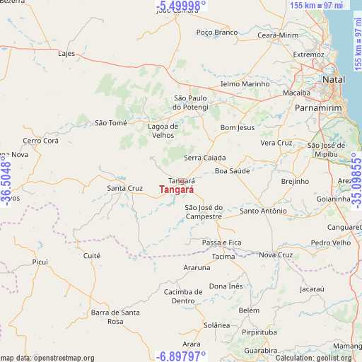
Tangará GPS coordinates[2]
6° 11' 57.984" South, 35° 48' 6.012" West
| Map corner | latitude | longitude |
|---|---|---|
| Upper-left | -5.49998°, | -36.5048° |
| Center: | -6.19944°, | -35.80167° |
| Lower-right: | -6.89797°, | -35.09855° |
| Map W x H: | 155.4×155.4 km | = 96.6×96.6mi |
| max Lat: | 2.81972° ⇑15.5% North |
| Tangará: | -6.19944° |
| min Lat: | ⇓84.5% South -33.69111° |
| min Long | Tangará | max Long |
| -72.89583° | -35.80167° | -32.41083° |
| W 93.7%⇐ | ⇒6.3% E |
Elevation
Elevation of Tangará is 188 m = 617 ft, and this is 192.9 m = 633 ft below average elevation for this country.
| Max E: |
1603 m = 5259 ft | 62.6% |
| Avg. | 380.9 m = 1250 ft | |
| Tangará | 188 m = 617 ft | |
Min E: |
0 m = 0 ft | 37.4% |
See also: Brazil elevation on elevation.city.
Geographical zone
Tangará is located in South Torrid zone (between Equator and Tropic of Capricorn). Distance of Equator is 689.3 km =428.3 mi to North.| Distance of | km | miles | from Tangará |
|---|---|---|---|
| Equator | 689.3 | 428.3 | to North |
| Tropic Capricorn | 1916.6 | 1190.9 | to South |
| Antarctic Circle | 6711.9 | 4170.6 | to South |
| South Pole | 9317.7 | 5789.7 | to South |


Nearby cities:
15 places around Tangará: (largest is in red/bold)
• Araruna
40.5 km =25.2 mi,  170°
170°
• Belém
62.2 km =38.6 mi,  151°
151°
• Brejinho
49.2 km =30.6 mi,  88°
88°
• Cacimba de Dentro
49.2 km =30.6 mi,  178°
178°
• Cerro Corá
62.5 km =38.8 mi,  285°
285°
• Cuité
50.1 km =31.1 mi,  230°
230°
• Dona Inês
49.9 km =31 mi,  157°
157°
• Macaíba
62.4 km =38.8 mi,  52°
52°
• Nova Cruz
51.1 km =31.8 mi,  127°
127°
• Nova Floresta
52.7 km =32.7 mi,  237°
237°
• Santa Cruz
24.7 km =15.3 mi,  262°
262°
• Santo Antônio
37.8 km =23.5 mi,  109°
109°
• São José do Campestre
16.2 km =10.1 mi,  143°
143°
• São Paulo do Potengi
34.1 km =21.2 mi,  7°
7°
• São Tomé
39.4 km =24.5 mi,  309°
309°
Sources, notices
• [Note1] Compared only with cities in Brazil existing in our database
• [Src1] Map data: © OpenStreetMap contributors (CC-BY-SA)
• [Src2] Other city data from geonames.org with taken over terms of usage.
• [Src3] Geographical zone / Annual Mean Temperature by Robert A. Rohde @ Wikipedia
