Nova Cruz geodata
Nova Cruz (Rio Grande do Norte) is a populated place; located in Brazil in America/Fortaleza (GMT-3) time zone. With population of 23,166 people, there are 826 cities with bigger population in this country. Compared to other cities in Brazil, 83.1% of cities are located further ↓South; 96.5% of cities are located further ←West and 73.6% of cities have higher elevation than Nova Cruz. Note1


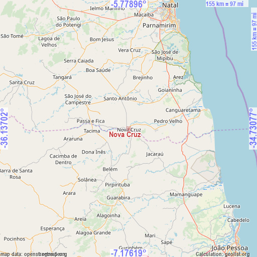
Nova Cruz GPS coordinates[2]
6° 28' 41.016" South, 35° 26' 2.004" West
| Map corner | latitude | longitude |
|---|---|---|
| Upper-left | -5.77896°, | -36.13702° |
| Center: | -6.47806°, | -35.43389° |
| Lower-right: | -7.17619°, | -34.73077° |
| Map W x H: | 155.4×155.4 km | = 96.6×96.6mi |
| max Lat: | 2.81972° ⇑16.9% North |
| Nova Cruz: | -6.47806° |
| min Lat: | ⇓83.1% South -33.69111° |
| min Long | Nova Cruz | max Long |
| -72.89583° | -35.43389° | -32.41083° |
| W 96.5%⇐ | ⇒3.5% E |
Elevation
Elevation of Nova Cruz is 90 m = 295 ft, and this is 290.9 m = 954 ft below average elevation for this country.
| Max E: |
1603 m = 5259 ft | 73.6% |
| Avg. | 380.9 m = 1250 ft | |
| Nova Cruz | 90 m = 295 ft | |
Min E: |
0 m = 0 ft | 26.4% |
See also: Brazil elevation on elevation.city.
Geographical zone
Nova Cruz is located in South Torrid zone (between Equator and Tropic of Capricorn). Distance of Equator is 720.3 km =447.6 mi to North.| Distance of | km | miles | from Nova Cruz |
|---|---|---|---|
| Equator | 720.3 | 447.6 | to North |
| Tropic Capricorn | 1885.6 | 1171.7 | to South |
| Antarctic Circle | 6680.9 | 4151.3 | to South |
| South Pole | 9286.8 | 5770.5 | to South |


Nearby cities:
15 places around Nova Cruz: (largest is in red/bold)
• Araruna
35.2 km =21.9 mi,  255°
255°
• Bananeiras
37.4 km =23.2 mi,  216°
216°
• Belém
26.2 km =16.3 mi,  204°
204°
• Brejinho
33.1 km =20.6 mi,  14°
14°
• Canguaretama
35.4 km =22 mi,  72°
72°
• Dona Inês
26.1 km =16.2 mi,  234°
234°
• Goianinha
34.1 km =21.2 mi,  45°
45°
• Guarabira
42.3 km =26.3 mi,  188°
188°
• Jacaraú
21.6 km =13.4 mi,  133°
133°
• Montanhas
16.2 km =10.1 mi,  93°
93°
• Pedro Velho
23.9 km =14.9 mi,  79°
79°
• Pirpirituba
34.3 km =21.3 mi, 192°
• Santo Antônio
19.3 km =12 mi,  345°
345°
• Solânea
32.9 km =20.4 mi, 200°
• São José do Campestre
35.8 km =22.2 mi,  300°
300°
Sources, notices
• [Note1] Compared only with cities in Brazil existing in our database
• [Src1] Map data: © OpenStreetMap contributors (CC-BY-SA)
• [Src2] Other city data from geonames.org with taken over terms of usage.
• [Src3] Geographical zone / Annual Mean Temperature by Robert A. Rohde @ Wikipedia
