Brejinho geodata
Brejinho (Rio Grande do Norte) is a populated place; located in Brazil in America/Fortaleza (GMT-3) time zone. With population of 7,625 people, there are 1796 cities with bigger population in this country. Compared to other cities in Brazil, 84.6% of cities are located further ↓South; 97% of cities are located further ←West and 67.1% of cities have higher elevation than Brejinho. Note1


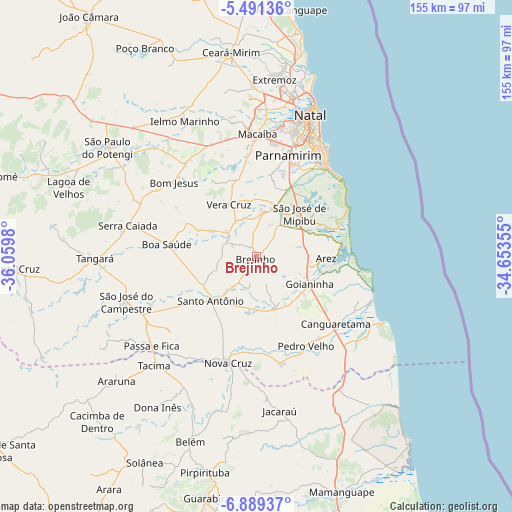
Brejinho GPS coordinates[2]
6° 11' 26.988" South, 35° 21' 24.012" West
| Map corner | latitude | longitude |
|---|---|---|
| Upper-left | -5.49136°, | -36.0598° |
| Center: | -6.19083°, | -35.35667° |
| Lower-right: | -6.88937°, | -34.65355° |
| Map W x H: | 155.4×155.4 km | = 96.6×96.6mi |
| max Lat: | 2.81972° ⇑15.4% North |
| Brejinho: | -6.19083° |
| min Lat: | ⇓84.6% South -33.69111° |
| min Long | Brejinho | max Long |
| -72.89583° | -35.35667° | -32.41083° |
| W 97%⇐ | ⇒3% E |
Elevation
Elevation of Brejinho is 151 m = 495 ft, and this is 229.9 m = 754 ft below average elevation for this country.
| Max E: |
1603 m = 5259 ft | 67.1% |
| Avg. | 380.9 m = 1250 ft | |
| Brejinho | 151 m = 495 ft | |
Min E: |
0 m = 0 ft | 32.9% |
See also: Brazil elevation on elevation.city.
Geographical zone
Brejinho is located in South Torrid zone (between Equator and Tropic of Capricorn). Distance of Equator is 688.4 km =427.8 mi to North.| Distance of | km | miles | from Brejinho |
|---|---|---|---|
| Equator | 688.4 | 427.8 | to North |
| Tropic Capricorn | 1917.6 | 1191.5 | to South |
| Antarctic Circle | 6712.8 | 4171.1 | to South |
| South Pole | 9318.7 | 5790.4 | to South |


Nearby cities:
15 places around Brejinho: (largest is in red/bold)
• Arês
21.7 km =13.5 mi,  91°
91°
• Canguaretama
32.8 km =20.4 mi,  129°
129°
• Goianinha
17.9 km =11.1 mi,  117°
117°
• Jacaraú
47.4 km =29.5 mi,  171°
171°
• Macaíba
37 km =23 mi,  0°
0°
• Montanhas
33.7 km =20.9 mi, 166°
• Natal
46.9 km =29.1 mi,  20°
20°
• Nova Cruz
33.1 km =20.6 mi,  194°
194°
• Nísia Floresta
19.8 km =12.3 mi,  55°
55°
• Parnamirim
32.3 km =20.1 mi, 18°
• Pedro Velho
31.4 km =19.5 mi,  151°
151°
• Santo Antônio
19 km =11.8 mi,  225°
225°
• São Gonçalo do Amarante
44.3 km =27.5 mi, 3°
• São José de Mipibu
18.4 km =11.4 mi,  45°
45°
• São José do Campestre
41.8 km =26 mi,  250°
250°
Sources, notices
• [Note1] Compared only with cities in Brazil existing in our database
• [Src1] Map data: © OpenStreetMap contributors (CC-BY-SA)
• [Src2] Other city data from geonames.org with taken over terms of usage.
• [Src3] Geographical zone / Annual Mean Temperature by Robert A. Rohde @ Wikipedia
