Redenção geodata
Redenção (Ceará) is a populated place; located in Brazil in America/Fortaleza (GMT-3) time zone. With population of 14,174 people, there are 1278 cities with bigger population in this country. Compared to other cities in Brazil, 90.6% of cities are located further ↓South; 81.6% of cities are located further ←West and 73.3% of cities have higher elevation than Redenção. Note1


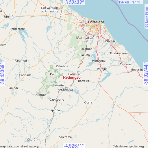
Redenção GPS coordinates[2]
4° 13' 32.988" South, 38° 43' 50.016" West
| Map corner | latitude | longitude |
|---|---|---|
| Upper-left | -3.52432°, | -39.43369° |
| Center: | -4.22583°, | -38.73056° |
| Lower-right: | -4.92671°, | -38.02744° |
| Map W x H: | 155.9×155.9 km | = 96.9×96.9mi |
| max Lat: | 2.81972° ⇑9.4% North |
| Redenção: | -4.22583° |
| min Lat: | ⇓90.6% South -33.69111° |
| min Long | Redenção | max Long |
| -72.89583° | -38.73056° | -32.41083° |
| W 81.6%⇐ | ⇒18.4% E |
Elevation
Elevation of Redenção is 93 m = 305 ft, and this is 287.9 m = 945 ft below average elevation for this country.
| Max E: |
1603 m = 5259 ft | 73.3% |
| Avg. | 380.9 m = 1250 ft | |
| Redenção | 93 m = 305 ft | |
Min E: |
0 m = 0 ft | 26.7% |
See also: Brazil elevation on elevation.city.
Geographical zone
Redenção is located in South Torrid zone (between Equator and Tropic of Capricorn). Distance of Equator is 469.9 km =292 mi to North.| Distance of | km | miles | from Redenção |
|---|---|---|---|
| Equator | 469.9 | 292 | to North |
| Tropic Capricorn | 2136.1 | 1327.3 | to South |
| Antarctic Circle | 6931.3 | 4306.9 | to South |
| South Pole | 9537.2 | 5926.1 | to South |


Nearby cities:
15 places around Redenção: (largest is in red/bold)
• Aquiraz
52.1 km =32.4 mi,  46°
46°
• Aracoiaba
18.6 km =11.6 mi,  209°
209°
• Baturité
20.6 km =12.8 mi,  236°
236°
• Cascavel
55.2 km =34.3 mi,  79°
79°
• Caucaia
55.1 km =34.2 mi,  8°
8°
• Chorozinho
27.1 km =16.8 mi,  107°
107°
• Eusébio
48.6 km =30.2 mi,  39°
39°
• Fortaleza
60.3 km =37.5 mi,  20°
20°
• Guaiúba
23.1 km =14.4 mi,  26°
26°
• Horizonte
30.8 km =19.1 mi,  62°
62°
• Itaitinga
36.3 km =22.6 mi, 38°
• Maracanaú
40.5 km =25.2 mi, 16°
• Ocara
33 km =20.5 mi,  153°
153°
• Pacajus
30.5 km =19 mi, 78°
• Pacatuba
29.5 km =18.3 mi, 24°
Sources, notices
• [Note1] Compared only with cities in Brazil existing in our database
• [Src1] Map data: © OpenStreetMap contributors (CC-BY-SA)
• [Src2] Other city data from geonames.org with taken over terms of usage.
• [Src3] Geographical zone / Annual Mean Temperature by Robert A. Rohde @ Wikipedia
