Caucaia geodata
Caucaia (Ceará) is a populated place; located in Brazil in America/Fortaleza (GMT-3) time zone. With population of 275,019 people, there are 80 cities with bigger population in this country. Compared to other cities in Brazil, 92.4% of cities are located further ↓South; 81.8% of cities are located further ←West and 83.5% of cities have higher elevation than Caucaia. Note1


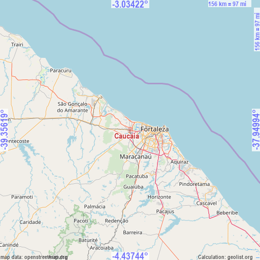
Caucaia GPS coordinates[2]
3° 44' 9.996" South, 38° 39' 11.016" West
| Map corner | latitude | longitude |
|---|---|---|
| Upper-left | -3.03422°, | -39.35619° |
| Center: | -3.73611°, | -38.65306° |
| Lower-right: | -4.43744°, | -37.94994° |
| Map W x H: | 156×156 km | = 96.9×96.9mi |
| max Lat: | 2.81972° ⇑7.6% North |
| Caucaia: | -3.73611° |
| min Lat: | ⇓92.4% South -33.69111° |
| min Long | Caucaia | max Long |
| -72.89583° | -38.65306° | -32.41083° |
| W 81.8%⇐ | ⇒18.2% E |
Elevation
Elevation of Caucaia is 35 m = 115 ft, and this is 345.9 m = 1135 ft below average elevation for this country.
| Max E: |
1603 m = 5259 ft | 83.5% |
| Avg. | 380.9 m = 1250 ft | |
| Caucaia | 35 m = 115 ft | |
Min E: |
0 m = 0 ft | 16.5% |
See also: Caucaia elevation on elevation.city.
Geographical zone
Caucaia is located in South Torrid zone (between Equator and Tropic of Capricorn). Distance of Equator is 415.4 km =258.1 mi to North.| Distance of | km | miles | from Caucaia |
|---|---|---|---|
| Equator | 415.4 | 258.1 | to North |
| Tropic Capricorn | 2190.5 | 1361.1 | to South |
| Antarctic Circle | 6985.8 | 4340.8 | to South |
| South Pole | 9591.6 | 5959.9 | to South |


Nearby cities:
15 places around Caucaia: (largest is in red/bold)
• Aquiraz
34.4 km =21.4 mi,  122°
122°
• Cambebba
23.4 km =14.5 mi,  303°
303°
• Cascavel
63.5 km =39.5 mi,  134°
134°
• Eusébio
28.2 km =17.5 mi, 127°
• Fortaleza
12.4 km =7.7 mi,  80°
80°
• Guaiúba
33.8 km =21 mi,  177°
177°
• Horizonte
44.6 km =27.7 mi,  155°
155°
• Itaitinga
29.4 km =18.3 mi,  151°
151°
• Jardim
54 km =33.6 mi, 303°
• Maracanaú
15.9 km =9.9 mi,  168°
168°
• Pacajus
53 km =32.9 mi, 156°
• Pacatuba
27.8 km =17.3 mi, 172°
• Paracuru
55.4 km =34.4 mi,  310°
310°
• Redenção
55.1 km =34.2 mi,  188°
188°
• São Gonçalo do Amarante
37.8 km =23.5 mi,  292°
292°
Sources, notices
• [Note1] Compared only with cities in Brazil existing in our database
• [Src1] Map data: © OpenStreetMap contributors (CC-BY-SA)
• [Src2] Other city data from geonames.org with taken over terms of usage.
• [Src3] Geographical zone / Annual Mean Temperature by Robert A. Rohde @ Wikipedia
