Cascavel geodata
Cascavel (Ceará) is a populated place; located in Brazil in America/Fortaleza (GMT-3) time zone. With population of 52,357 people, there are 414 cities with bigger population in this country. Compared to other cities in Brazil, 91% of cities are located further ↓South; 83.6% of cities are located further ←West and 84.8% of cities have higher elevation than Cascavel. Note1


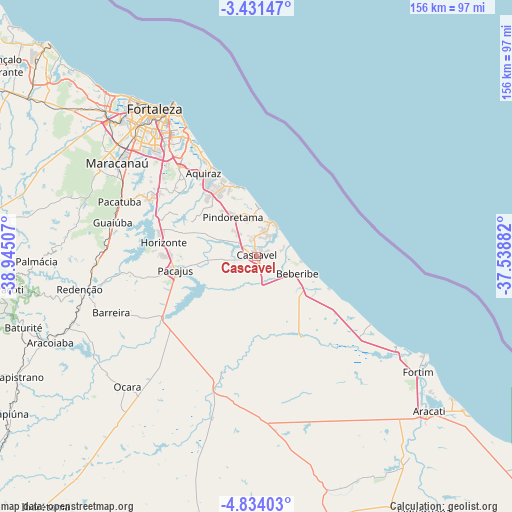
Cascavel GPS coordinates[2]
4° 7' 59.016" South, 38° 14' 30.984" West
| Map corner | latitude | longitude |
|---|---|---|
| Upper-left | -3.43147°, | -38.94507° |
| Center: | -4.13306°, | -38.24194° |
| Lower-right: | -4.83403°, | -37.53882° |
| Map W x H: | 156×156 km | = 96.9×96.9mi |
| max Lat: | 2.81972° ⇑9% North |
| Cascavel: | -4.13306° |
| min Lat: | ⇓91% South -33.69111° |
| min Long | Cascavel | max Long |
| -72.89583° | -38.24194° | -32.41083° |
| W 83.6%⇐ | ⇒16.4% E |
Elevation
Elevation of Cascavel is 31 m = 102 ft, and this is 349.9 m = 1148 ft below average elevation for this country.
| Max E: |
1603 m = 5259 ft | 84.8% |
| Avg. | 380.9 m = 1250 ft | |
| Cascavel | 31 m = 102 ft | |
Min E: |
0 m = 0 ft | 15.2% |
See also: Cascavel elevation on elevation.city.
Geographical zone
Cascavel is located in South Torrid zone (between Equator and Tropic of Capricorn). Distance of Equator is 459.6 km =285.6 mi to North.| Distance of | km | miles | from Cascavel |
|---|---|---|---|
| Equator | 459.6 | 285.6 | to North |
| Tropic Capricorn | 2146.4 | 1333.7 | to South |
| Antarctic Circle | 6941.6 | 4313.3 | to South |
| South Pole | 9547.5 | 5932.5 | to South |


Nearby cities:
15 places around Cascavel: (largest is in red/bold)
• Aquiraz
30.6 km =19 mi,  327°
327°
• Aracoiaba
68.8 km =42.8 mi,  247°
247°
• Beberibe
13.4 km =8.3 mi,  112°
112°
• Caucaia
63.5 km =39.5 mi,  314°
314°
• Chorozinho
33.9 km =21.1 mi,  236°
236°
• Eusébio
35.6 km =22.1 mi,  319°
319°
• Fortaleza
57 km =35.4 mi, 324°
• Guaiúba
45.1 km =28 mi,  283°
283°
• Horizonte
27 km =16.8 mi, 277°
• Itaitinga
36.6 km =22.7 mi,  299°
299°
• Maracanaú
51.2 km =31.8 mi, 303°
• Ocara
55.9 km =34.7 mi,  224°
224°
• Pacajus
24.6 km =15.3 mi,  259°
259°
• Pacatuba
45.1 km =28 mi,  291°
291°
• Redenção
55.2 km =34.3 mi, 259°
Sources, notices
• [Note1] Compared only with cities in Brazil existing in our database
• [Src1] Map data: © OpenStreetMap contributors (CC-BY-SA)
• [Src2] Other city data from geonames.org with taken over terms of usage.
• [Src3] Geographical zone / Annual Mean Temperature by Robert A. Rohde @ Wikipedia
