Fortaleza geodata
Fortaleza (Ceará) is a seat of a first-order administrative division; located in Brazil in America/Fortaleza (GMT-3) time zone. With population of 2,400,000 people, there are 3 cities with bigger population in this country. Compared to other cities in Brazil, 92.6% of cities are located further ↓South; 82.3% of cities are located further ←West and 89.9% of cities have higher elevation than Fortaleza. Note1


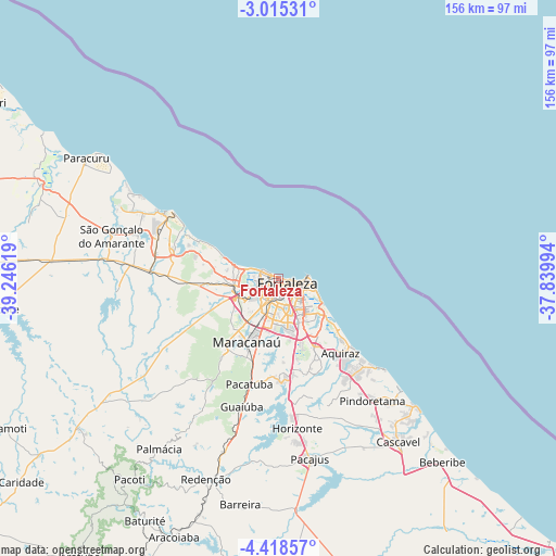
Fortaleza GPS coordinates[2]
3° 43' 1.992" South, 38° 32' 35.016" West
| Map corner | latitude | longitude |
|---|---|---|
| Upper-left | -3.01531°, | -39.24619° |
| Center: | -3.71722°, | -38.54306° |
| Lower-right: | -4.41857°, | -37.83994° |
| Map W x H: | 156×156 km | = 96.9×96.9mi |
| max Lat: | 2.81972° ⇑7.4% North |
| Fortaleza: | -3.71722° |
| min Lat: | ⇓92.6% South -33.69111° |
| min Long | Fortaleza | max Long |
| -72.89583° | -38.54306° | -32.41083° |
| W 82.3%⇐ | ⇒17.7% E |
Elevation
Elevation of Fortaleza is 18 m = 59 ft, and this is 362.9 m = 1191 ft below average elevation for this country.
| Max E: |
1603 m = 5259 ft | 89.9% |
| Avg. | 380.9 m = 1250 ft | |
| Fortaleza | 18 m = 59 ft | |
Min E: |
0 m = 0 ft | 10.1% |
See also: Fortaleza elevation on elevation.city.
Geographical zone
Fortaleza is located in South Torrid zone (between Equator and Tropic of Capricorn). Distance of Equator is 413.3 km =256.8 mi to North.| Distance of | km | miles | from Fortaleza |
|---|---|---|---|
| Equator | 413.3 | 256.8 | to North |
| Tropic Capricorn | 2192.6 | 1362.4 | to South |
| Antarctic Circle | 6987.9 | 4342.1 | to South |
| South Pole | 9593.7 | 5961.2 | to South |


Nearby cities:
15 places around Fortaleza: (largest is in red/bold)
• Aquiraz
26.5 km =16.5 mi,  140°
140°
• Cambebba
33.5 km =20.8 mi,  288°
288°
• Cascavel
57 km =35.4 mi, 144°
• Caucaia
12.4 km =7.7 mi,  260°
260°
• Eusébio
21.8 km =13.5 mi,  151°
151°
• Guaiúba
37.3 km =23.2 mi,  196°
196°
• Horizonte
43.1 km =26.8 mi,  171°
171°
• Itaitinga
28.1 km =17.5 mi,  176°
176°
• Jardim
63.5 km =39.5 mi,  296°
296°
• Maracanaú
20 km =12.4 mi,  207°
207°
• Pacajus
51.4 km =31.9 mi, 169°
• Pacatuba
30.9 km =19.2 mi, 196°
• Paracuru
64 km =39.8 mi, 302°
• Redenção
60.3 km =37.5 mi, 200°
• São Gonçalo do Amarante
48.7 km =30.3 mi,  284°
284°
Sources, notices
• [Note1] Compared only with cities in Brazil existing in our database
• [Src1] Map data: © OpenStreetMap contributors (CC-BY-SA)
• [Src2] Other city data from geonames.org with taken over terms of usage.
• [Src3] Geographical zone / Annual Mean Temperature by Robert A. Rohde @ Wikipedia
