Raposa geodata
Raposa (Maranhão) is a populated place; located in Brazil in America/Fortaleza (GMT-3) time zone. With population of 11,883 people, there are 1491 cities with bigger population in this country. Compared to other cities in Brazil, 82.9% of cities are located further ↓South; 54.9% of cities are located further ←West and 52.7% of cities have lower elevation than Raposa. Note1


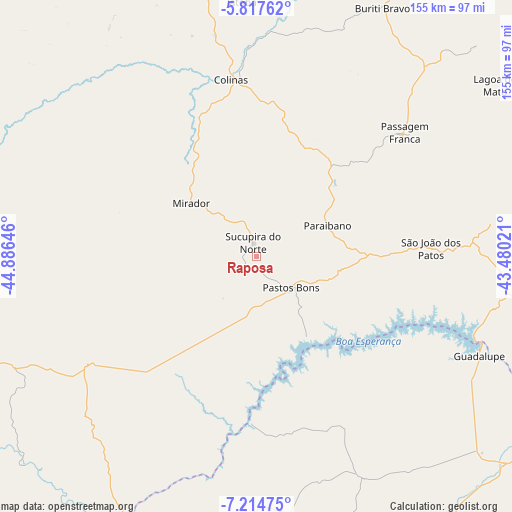
Raposa GPS coordinates[2]
6° 31' 0.012" South, 44° 10' 59.988" West
| Map corner | latitude | longitude |
|---|---|---|
| Upper-left | -5.81762°, | -44.88646° |
| Center: | -6.51667°, | -44.18333° |
| Lower-right: | -7.21475°, | -43.48021° |
| Map W x H: | 155.3×155.4 km | = 96.5×96.6mi |
| max Lat: | 2.81972° ⇑17.1% North |
| Raposa: | -6.51667° |
| min Lat: | ⇓82.9% South -33.69111° |
| min Long | Raposa | max Long |
| -72.89583° | -44.18333° | -32.41083° |
| W 54.9%⇐ | ⇒45.1% E |
Elevation
Elevation of Raposa is 387 m = 1270 ft, and this is 6.1 m = 20 ft above average elevation for this country.
| Max E: |
1603 m = 5259 ft | 47.3% |
| Raposa | 387 m 1270 ft | |
| Avg. | 380.9 m = 1250 ft | |
Min E: |
0 m = 0 ft | 52.7% |
See also: Brazil elevation on elevation.city.
Geographical zone
Raposa is located in South Torrid zone (between Equator and Tropic of Capricorn). Distance of Equator is 724.6 km =450.2 mi to North.| Distance of | km | miles | from Raposa |
|---|---|---|---|
| Equator | 724.6 | 450.2 | to North |
| Tropic Capricorn | 1881.3 | 1169 | to South |
| Antarctic Circle | 6676.6 | 4148.6 | to South |
| South Pole | 9282.5 | 5767.9 | to South |


Nearby cities:
15 places around Raposa: (largest is in red/bold)
• Buriti Bravo
84.9 km =52.8 mi,  27°
27°
• Colinas
55.1 km =34.2 mi,  352°
352°
• Estreito
131.5 km =81.7 mi,  51°
51°
• Floriano
131.2 km =81.5 mi,  102°
102°
• Fortuna
87.1 km =54.1 mi,  1°
1°
• Mirador
25.6 km =15.9 mi,  309°
309°
• Palmeirais
137.5 km =85.4 mi,  64°
64°
• Paraibano
23.9 km =14.9 mi,  67°
67°
• Passagem Franca
57.9 km =36 mi, 49°
• Pastos Bons
15.1 km =9.4 mi,  128°
128°
• Presidente Dutra
140.5 km =87.3 mi, 346°
• São Domingos do Maranhão
107 km =66.5 mi, 347°
• São João dos Patos
53.2 km =33.1 mi,  87°
87°
• Tuntum
149.1 km =92.6 mi,  339°
339°
• Uruçuí
89.3 km =55.5 mi,  207°
207°
Sources, notices
• [Note1] Compared only with cities in Brazil existing in our database
• [Src1] Map data: © OpenStreetMap contributors (CC-BY-SA)
• [Src2] Other city data from geonames.org with taken over terms of usage.
• [Src3] Geographical zone / Annual Mean Temperature by Robert A. Rohde @ Wikipedia
