Mirador geodata
Mirador (Maranhão) is a populated place; located in Brazil in America/Fortaleza (GMT-3) time zone. With population of 6,955 people, there are 1833 cities with bigger population in this country. Compared to other cities in Brazil, 83.7% of cities are located further ↓South; 53.9% of cities are located further ←West and 63.9% of cities have higher elevation than Mirador. Note1


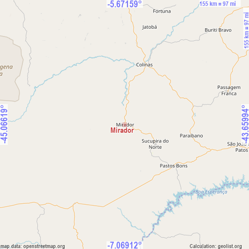
Mirador GPS coordinates[2]
6° 22' 14.988" South, 44° 21' 47.016" West
| Map corner | latitude | longitude |
|---|---|---|
| Upper-left | -5.67159°, | -45.06619° |
| Center: | -6.37083°, | -44.36306° |
| Lower-right: | -7.06912°, | -43.65994° |
| Map W x H: | 155.4×155.4 km | = 96.6×96.6mi |
| max Lat: | 2.81972° ⇑16.3% North |
| Mirador: | -6.37083° |
| min Lat: | ⇓83.7% South -33.69111° |
| min Long | Mirador | max Long |
| -72.89583° | -44.36306° | -32.41083° |
| W 53.9%⇐ | ⇒46.1% E |
Elevation
Elevation of Mirador is 176 m = 577 ft, and this is 204.9 m = 672 ft below average elevation for this country.
| Max E: |
1603 m = 5259 ft | 63.9% |
| Avg. | 380.9 m = 1250 ft | |
| Mirador | 176 m = 577 ft | |
Min E: |
0 m = 0 ft | 36.1% |
See also: Brazil elevation on elevation.city.
Geographical zone
Mirador is located in South Torrid zone (between Equator and Tropic of Capricorn). Distance of Equator is 708.4 km =440.2 mi to North.| Distance of | km | miles | from Mirador |
|---|---|---|---|
| Equator | 708.4 | 440.2 | to North |
| Tropic Capricorn | 1897.5 | 1179.1 | to South |
| Antarctic Circle | 6692.8 | 4158.7 | to South |
| South Pole | 9298.7 | 5777.9 | to South |


Nearby cities:
15 places around Mirador: (largest is in red/bold)
• Barra do Corda
136.9 km =85.1 mi,  314°
314°
• Buriti Bravo
83.3 km =51.8 mi,  44°
44°
• Colinas
40.4 km =25.1 mi,  18°
18°
• Estreito
139.3 km =86.6 mi,  62°
62°
• Fortuna
74.4 km =46.2 mi, 17°
• Paraibano
42.5 km =26.4 mi,  99°
99°
• Passagem Franca
67.5 km =41.9 mi,  71°
71°
• Pastos Bons
40.7 km =25.3 mi,  129°
129°
• Presidente Dutra
121 km =75.2 mi,  353°
353°
• Raposa
25.6 km =15.9 mi, 129°
• São Domingos do Maranhão
88.4 km =54.9 mi,  358°
358°
• São João dos Patos
74.3 km =46.2 mi, 100°
• São Raimundo das Mangabeiras
143.1 km =88.9 mi,  239°
239°
• Tuntum
127.7 km =79.3 mi, 345°
• Uruçuí
97.8 km =60.8 mi,  192°
192°
Sources, notices
• [Note1] Compared only with cities in Brazil existing in our database
• [Src1] Map data: © OpenStreetMap contributors (CC-BY-SA)
• [Src2] Other city data from geonames.org with taken over terms of usage.
• [Src3] Geographical zone / Annual Mean Temperature by Robert A. Rohde @ Wikipedia
