Fortuna geodata
Fortuna (Maranhão) is a populated place; located in Brazil in America/Fortaleza (GMT-3) time zone. With population of 9,755 people, there are 1667 cities with bigger population in this country. Compared to other cities in Brazil, 86.3% of cities are located further ↓South; 55.1% of cities are located further ←West and 60.2% of cities have higher elevation than Fortuna. Note1


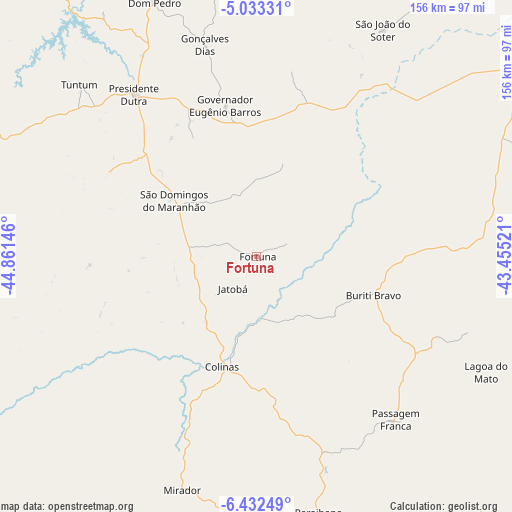
Fortuna GPS coordinates[2]
5° 43' 59.988" South, 44° 9' 29.988" West
| Map corner | latitude | longitude |
|---|---|---|
| Upper-left | -5.03331°, | -44.86146° |
| Center: | -5.73333°, | -44.15833° |
| Lower-right: | -6.43249°, | -43.45521° |
| Map W x H: | 155.6×155.6 km | = 96.7×96.7mi |
| max Lat: | 2.81972° ⇑13.7% North |
| Fortuna: | -5.73333° |
| min Lat: | ⇓86.3% South -33.69111° |
| min Long | Fortuna | max Long |
| -72.89583° | -44.15833° | -32.41083° |
| W 55.1%⇐ | ⇒44.9% E |
Elevation
Elevation of Fortuna is 210 m = 689 ft, and this is 170.9 m = 561 ft below average elevation for this country.
| Max E: |
1603 m = 5259 ft | 60.2% |
| Avg. | 380.9 m = 1250 ft | |
| Fortuna | 210 m = 689 ft | |
Min E: |
0 m = 0 ft | 39.8% |
See also: Brazil elevation on elevation.city.
Geographical zone
Fortuna is located in South Torrid zone (between Equator and Tropic of Capricorn). Distance of Equator is 637.5 km =396.1 mi to North.| Distance of | km | miles | from Fortuna |
|---|---|---|---|
| Equator | 637.5 | 396.1 | to North |
| Tropic Capricorn | 1968.4 | 1223.1 | to South |
| Antarctic Circle | 6763.7 | 4202.8 | to South |
| South Pole | 9369.6 | 5822 | to South |


Nearby cities:
15 places around Fortuna: (largest is in red/bold)
• Buriti Bravo
37.7 km =23.4 mi,  107°
107°
• Colinas
34 km =21.1 mi,  197°
197°
• Dom Pedro
83.4 km =51.8 mi,  338°
338°
• Esperantinópolis
114 km =70.8 mi,  327°
327°
• Estreito
100.6 km =62.5 mi,  93°
93°
• Mirador
74.4 km =46.2 mi, 197°
• Paraibano
80.2 km =49.8 mi,  166°
166°
• Parnarama
118 km =73.3 mi, 87°
• Passagem Franca
64.7 km =40.2 mi,  140°
140°
• Pastos Bons
97 km =60.3 mi, 174°
• Presidente Dutra
61.5 km =38.2 mi,  323°
323°
• Raposa
87.1 km =54.1 mi,  181°
181°
• São Domingos do Maranhão
30.6 km =19 mi,  304°
304°
• São João dos Patos
98.6 km =61.3 mi,  149°
149°
• Tuntum
75.8 km =47.1 mi,  314°
314°
Sources, notices
• [Note1] Compared only with cities in Brazil existing in our database
• [Src1] Map data: © OpenStreetMap contributors (CC-BY-SA)
• [Src2] Other city data from geonames.org with taken over terms of usage.
• [Src3] Geographical zone / Annual Mean Temperature by Robert A. Rohde @ Wikipedia
