Palmares geodata
Palmares (Pernambuco) is a populated place; located in Brazil in America/Recife (GMT-3) time zone. With population of 41,679 people, there are 506 cities with bigger population in this country. Compared to other cities in Brazil, 72.4% of cities are located further ↓South; 95.2% of cities are located further ←West and 71.1% of cities have higher elevation than Palmares. Note1


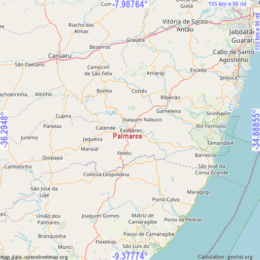
Palmares GPS coordinates[2]
8° 40' 59.988" South, 35° 35' 30.012" West
| Map corner | latitude | longitude |
|---|---|---|
| Upper-left | -7.98764°, | -36.2948° |
| Center: | -8.68333°, | -35.59167° |
| Lower-right: | -9.37774°, | -34.88855° |
| Map W x H: | 154.6×154.6 km | = 96.1×96.1mi |
| max Lat: | 2.81972° ⇑27.6% North |
| Palmares: | -8.68333° |
| min Lat: | ⇓72.4% South -33.69111° |
| min Long | Palmares | max Long |
| -72.89583° | -35.59167° | -32.41083° |
| W 95.2%⇐ | ⇒4.8% E |
Elevation
Elevation of Palmares is 115 m = 377 ft, and this is 265.9 m = 872 ft below average elevation for this country.
| Max E: |
1603 m = 5259 ft | 71.1% |
| Avg. | 380.9 m = 1250 ft | |
| Palmares | 115 m = 377 ft | |
Min E: |
0 m = 0 ft | 28.9% |
See also: Palmares elevation on elevation.city.
Geographical zone
Palmares is located in South Torrid zone (between Equator and Tropic of Capricorn). Distance of Equator is 965.5 km =599.9 mi to North.| Distance of | km | miles | from Palmares |
|---|---|---|---|
| Equator | 965.5 | 599.9 | to North |
| Tropic Capricorn | 1640.4 | 1019.3 | to South |
| Antarctic Circle | 6435.7 | 3999 | to South |
| South Pole | 9041.6 | 5618.2 | to South |


Nearby cities:
15 places around Palmares: (largest is in red/bold)
• Amaraji
36.7 km =22.8 mi,  24°
24°
• Bonito
28.1 km =17.5 mi,  327°
327°
• Camocim de São Félix
40.7 km =25.3 mi, 332°
• Catende
13.9 km =8.6 mi,  277°
277°
• Colônia Leopoldina
29 km =18 mi,  210°
210°
• Cupira
40.1 km =24.9 mi, 280°
• Gameleira
25.1 km =15.6 mi,  63°
63°
• Guabiraba
30.8 km =19.1 mi,  344°
344°
• Joaquim Nabuco
9.2 km =5.7 mi,  44°
44°
• Jundiá
28 km =17.4 mi,  175°
175°
• Maraial
26.3 km =16.3 mi,  245°
245°
• Novo Lino
26.5 km =16.5 mi,  193°
193°
• Ribeirão
30.1 km =18.7 mi,  51°
51°
• São Joaquim do Monte
36.4 km =22.6 mi,  320°
320°
• Água Preta
7.2 km =4.5 mi,  111°
111°
Sources, notices
• [Note1] Compared only with cities in Brazil existing in our database
• [Src1] Map data: © OpenStreetMap contributors (CC-BY-SA)
• [Src2] Other city data from geonames.org with taken over terms of usage.
• [Src3] Geographical zone / Annual Mean Temperature by Robert A. Rohde @ Wikipedia
